Timezone:Mountain Standard Time
Current Time:Monday, November 9, 2026 6:08 AM
Longitude:-110.770938
Latitude:32.9875659
Sunrise Time Today:6:49:31 AM
Sunset Time Today:5:26:59 PM
Daylength Today:10h 37m 28s
Sunrise Time Tomorrow:6:50:26 AM
Sunset Time Tomorrow:5:26:17 PM
Daylength Tomorrow:10h 35m 51s

: Show All Dates

Date Sunrise Time Sunset Time Daylength
Jan 1, 2026 7:27:04 AM 5:27:39 PM 10h 0m 34s
Feb 1, 2026 7:20:18 AM 5:55:15 PM 10h 34m 57s
Mar 1, 2026 6:53:45 AM 6:20:26 PM 11h 26m 40s
Apr 1, 2026 6:13:25 AM 6:43:20 PM 12h 29m 54s
May 1, 2026 5:37:45 AM 7:05:13 PM 13h 27m 28s
Jun 1, 2026 5:17:10 AM 7:27:18 PM 14h 10m 7s
Jul 1, 2026 5:18:54 AM 7:36:54 PM 14h 18m 0s
Aug 1, 2026 5:37:01 AM 7:24:20 PM 13h 47m 19s
Sep 1, 2026 5:58:22 AM 6:51:27 PM 12h 53m 5s
Oct 1, 2026 6:17:44 AM 6:10:51 PM 11h 53m 7s
Nov 1, 2026 6:41:27 AM 5:34:23 PM 10h 52m 55s
Nov 9, 2026 6:48:36 AM 5:27:43 PM 10h 39m 6s
Nov 10, 2026 6:49:31 AM 5:26:59 PM 10h 37m 28s
Dec 1, 2026 7:08:38 AM 5:17:55 PM 10h 9m 17s

Sunrise & Sunset Photos

Aries by CEBImagery.com, Aries

Model Liana Riveranaked aries arizona back beauty cactus copper corridor desert model natural
Aries by CEBImagery.com
Sunset in the Desert, N of Zapata Wash, San Pedro River Valley, N of Mammoth, AZ - Color Photo Art by Lon&Queta, Abe’s Garden, N of Zapata Wash, E of Highway 77, San Pedro River Valley, N of Mammoth, AZ - Color Ph
Sunset in the Desert, N of Zapata Wash, San Pedro River Valley, N of Mammoth, AZ - Color Photo Art by Lon&Queta
Aravaipa Canyon approach - Brandenburg Mountain and Ranger's house at Sunrise (EXPLORE) by Al_HikesAZ, This is Brandenburg Mountain and Brandenburg Ranger Station at Sunrise as I approach Aravaipa Canyon
Aravaipa Canyon approach - Brandenburg Mountain and Ranger's house at Sunrise (EXPLORE) by Al_HikesAZ
Cholla Sunset, N of Zapata Wash, San Pedro River Valley, N of Mammoth, AZ - Color Photo Art by Lon&Queta, Abe’s Garden, named after Abe Yañez, who first showed us this area, N of Zapata Wash, San Pedro Rive
Cholla Sunset, N of Zapata Wash, San Pedro River Valley, N of Mammoth, AZ - Color Photo Art by Lon&Queta
Sonoran Desert Sunset, N of Zapata Wash, San Pedro River Valley, N of Mammoth, AZ by Lon&Queta, Abe’s Garden, N of Zapata Wash, E of Highway 77, San Pedro River Valley, N of Mammoth, AZ2023 arizon
Sonoran Desert Sunset, N of Zapata Wash, San Pedro River Valley, N of Mammoth, AZ by Lon&Queta
Morning rituals by Moffat Road, Just after sunrise at 6:13 a.m. on April 21, 2017, a Copper Basin Railway employee goes about the mo
Morning rituals by Moffat Road
Desert Dusk by Dave Blaze Rail Photography, This is a very high ISO image and a bit grainy considering it pushed the low light capabilities of t
Desert Dusk by Dave Blaze Rail Photography
Moonset - Aravaipa Canyon by Al_HikesAZ, I was greeted by the sunrise.  I was bid goodbye by the moon setting.  Aravaipa Canyon is a magical
Moonset - Aravaipa Canyon by Al_HikesAZ
Aravaipa Evening by isaac.borrego, water stream evening sunset trees creek aravaipacanyon arizona canonrebelxsi canyon desert unitedsta
Aravaipa Evening by isaac.borrego
Setting sun with Saguaro and Ocotillo; "Buckhorn Flats" N of Zapata Wash road to Holy Joe Canyon, NE of Mammoth, AZ by Lon&Queta, Setting sun with Saguaro and Ocotillo; "Buckhorn Flats" N of Zapata Wash road to Holy Joe
Setting sun with Saguaro and Ocotillo; "Buckhorn Flats" N of Zapata Wash road to Holy Joe Canyon, NE of Mammoth, AZ by Lon&Queta
Setting sun with Saguaro and Jumping Cholla Cacti; "Buckhorn Flats" N of Zapata Wash road to Holy Joe Canyon, NE of Mammoth, AZ by Lon&Queta, Setting sun with Saguaro and Jumping Cholla Cacti; "Buckhorn Flats" N of Zapata Wash road
Setting sun with Saguaro and Jumping Cholla Cacti; "Buckhorn Flats" N of Zapata Wash road to Holy Joe Canyon, NE of Mammoth, AZ by Lon&Queta
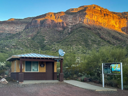
Brandenburg Ranger's station at sunrise - Aravaipa Canyon approach by Al_HikesAZ, This is the Brandenburg Ranger Station Kiosk at Sunrise as I approach Aravaipa Canyon from the west.
Brandenburg Ranger's station at sunrise - Aravaipa Canyon approach by Al_HikesAZ
Aravaipa Canyon approach - Brandenburg Mountain and Ranger's house at Sunrise by Al_HikesAZ, This is Brandenburg Mountain and Brandenburg Ranger Station at Sunrise as I approach Aravaipa Canyon
Aravaipa Canyon approach - Brandenburg Mountain and Ranger's house at Sunrise by Al_HikesAZ
Sunset at Abe’s Garden, N of Zapata Wash, San Pedro River Valley, N of Mammoth, AZ by Lon&Queta, Abe’s Garden named after an old friend who first showed us the area, N of Zapata Wash, San Pedro Riv
Sunset at Abe’s Garden, N of Zapata Wash, San Pedro River Valley, N of Mammoth, AZ by Lon&Queta
Sunset in the Sonoran Desert, N of Zapata Wash, San Pedro River Valley, N of Mammoth, AZ by Lon&Queta, N of Zapata Wash, San Pedro River Valley, N of Mammoth, AZarizona usa cacti landscapes flickr desert
Sunset in the Sonoran Desert, N of Zapata Wash, San Pedro River Valley, N of Mammoth, AZ by Lon&Queta
Saguaro Sunset, N of Zapata Wash, San Pedro River Valley, N of Mammoth, AZ by Lon&Queta, Abe’s Garden, N of Zapata Wash, E of Highway 77, San Pedro River Valley, N of Mammoth, AZ2023 arizon
Saguaro Sunset, N of Zapata Wash, San Pedro River Valley, N of Mammoth, AZ by Lon&Queta
Sunset at Abe’s Garden, N of Zapata Wash, San Pedro River Valley, N of Mammoth, AZ - Color Photo Art by Lon&Queta, We call this place Abe’s Garden, after Abe Yañez, a previous neighbor, miner, part Yaqui, part Apach
Sunset at Abe’s Garden, N of Zapata Wash, San Pedro River Valley, N of Mammoth, AZ - Color Photo Art by Lon&Queta
Setting sun with Saguaro and Jumping Cholla Cacti; "Buckhorn Flats" N of Zapata Wash road to Holy Joe Canyon, NE of Mammoth, AZ (1) by Lon&Queta, Setting sun with Saguaro and Jumping Cholla Cacti; "Buckhorn Flats" N of Zapata Wash road
Setting sun with Saguaro and Jumping Cholla Cacti; "Buckhorn Flats" N of Zapata Wash road to Holy Joe Canyon, NE of Mammoth, AZ (1) by Lon&Queta
Last Light - Abe’s Garden, N of Zapata Wash, San Pedro River Valley, N of Mammoth, AZ by Lon&Queta, Abe’s Garden (a beautiful area that an old friend of ours originally showed us, out in the middle of
Last Light - Abe’s Garden, N of Zapata Wash, San Pedro River Valley, N of Mammoth, AZ by Lon&Queta
Sonoran Desert Sunset, N of Zapata Wash, San Pedro River Valley, N of Mammoth, AZ - Color Photo Art by Lon&Queta, Abe’s Garden, named after a friend who first showed us this area, N of Zapata Wash, San Pedro River
Sonoran Desert Sunset, N of Zapata Wash, San Pedro River Valley, N of Mammoth, AZ - Color Photo Art by Lon&Queta
Saguaro at Sunset, N of Zapata Wash, E of Highway 77, San Pedro River Valley, N of Mammoth, AZ by Lon&Queta, Abe’s Garden, N of Zapata Wash, E of Highway 77, San Pedro River Valley, N of Mammoth, AZarizona usa
Saguaro at Sunset, N of Zapata Wash, E of Highway 77, San Pedro River Valley, N of Mammoth, AZ by Lon&Queta
Abe’s Garden with Ocotillo art Sunset, N of Zapata Wash, San Pedro River Valley, N of Mammoth, AZ by Lon&Queta, Abe’s Garden, a place we named after an old friend of ours Abe Yañez, who showed it to us, N of Zapa
Abe’s Garden with Ocotillo art Sunset, N of Zapata Wash, San Pedro River Valley, N of Mammoth, AZ by Lon&Queta
Saguaro at Sunset; N of Kelvin - Florence road, Tortilla Mountains, W of Kearny, AZ by Lon&Queta, Campsite; N of Kelvin - Florence road, Tortilla Mountains, W of Kearny, AZ2008 arizona cacti desert
Saguaro at Sunset; N of Kelvin - Florence road, Tortilla Mountains, W of Kearny, AZ by Lon&Queta
Sunset N of Zapata Wash, E of Highway 77, San Pedro River Valley, N of Mammoth, AZ - Color Photo Art by Lon&Queta, A place we call "Abe’s Garden" because Abe Yañez was the person who showed it to us; N of
Sunset N of Zapata Wash, E of Highway 77, San Pedro River Valley, N of Mammoth, AZ - Color Photo Art by Lon&Queta
Sunset in a special place; N of Zapata Wash, E of Highway 77, San Pedro River Valley, N of Mammoth, AZ by Lon&Queta, Abe’s Garden, N of Zapata Wash, E of Highway 77, San Pedro River Valley, N of Mammoth, AZarizona cac
Sunset in a special place; N of Zapata Wash, E of Highway 77, San Pedro River Valley, N of Mammoth, AZ by Lon&Queta
Saguaro Sunset, N of Zapata Wash, E of Highway 77, San Pedro River Valley, N of Mammoth, AZ by Lon&Queta, Abe’s Garden, N of Zapata Wash, E of Highway 77, San Pedro River Valley, N of Mammoth, AZarizona usa
Saguaro Sunset, N of Zapata Wash, E of Highway 77, San Pedro River Valley, N of Mammoth, AZ by Lon&Queta
Jumping Cholla Cactus, N of Zapata Wash, San Pedro River Valley, N of Mammoth, AZ by Lon&Queta, Abe’s Garden, N of Zapata Wash, E of Highway 77, San Pedro River Valley, N of Mammoth, AZ2023 arizon
Jumping Cholla Cactus, N of Zapata Wash, San Pedro River Valley, N of Mammoth, AZ by Lon&Queta
Palo Verde Tree at sunset, N of Kelvin - Florence road, Tortilla Mountains, W of Kearny, AZ by Lon&Queta, Palo Verde Tree; N of Kelvin - Florence road, Tortilla Mountains, W of Kearny, AZ2008 arizona banana
Palo Verde Tree at sunset, N of Kelvin - Florence road, Tortilla Mountains, W of Kearny, AZ by Lon&Queta
Teddy Bear Chola at Sunset, N of Zapata Wash, E of Highway 77, San Pedro River Valley, N of Mammoth, AZ by Lon&Queta, Abe’s Garden, N of Zapata Wash, E of Highway 77, San Pedro River Valley, N of Mammoth, AZ2023 arizon
Teddy Bear Chola at Sunset, N of Zapata Wash, E of Highway 77, San Pedro River Valley, N of Mammoth, AZ by Lon&Queta
Sunset; Tortilla Mountains, W of Kearny, AZ by Lon&Queta, Sunset; N of Kelvin - Florence road, Tortilla Mountains, W of Kearny, AZ2008 arizona cacti desert fl
Sunset; Tortilla Mountains, W of Kearny, AZ by Lon&Queta
Campsite; N of Kelvin - Florence road, Tortilla Mountains, W of Kearny, AZ by Lon&Queta, Campsite;N of Kelvin - Florence road, Tortilla Mountains, W of Kearny, AZ2008 arizona cacti desert f
Campsite; N of Kelvin - Florence road, Tortilla Mountains, W of Kearny, AZ by Lon&Queta
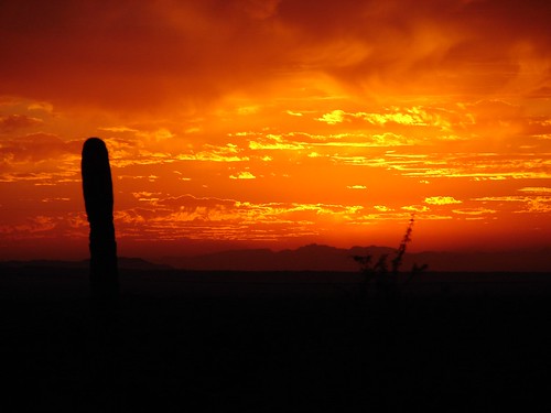
2ndNight'sSunset04 by galiuros, Along the Arizona Trail between Freeman Road and Kelvin Bridge.sunset arizonatrail
2ndNight'sSunset04 by galiuros
CBRY505_Kearny by johndbireland,
CBRY505_Kearny by johndbireland
120910-039-San Carlos Lake-Arizona by skw9413,      Late afternoon lighting created some interesting shadows as the darkened sandbar indicates in t
120910-039-San Carlos Lake-Arizona by skw9413
120910-019-San Carlos Lake At Coolidge Dam by skw9413,      Late afternoon shadows poke out onto the San Carlos Lake at the inlet side of the Coolidge Dam
120910-019-San Carlos Lake At Coolidge Dam by skw9413