Calapooia, OR 美國的日出日落時間表
Location: 美國 > 俄勒冈州 > 林縣 >
時區:
America/Los_Angeles
當地時間:
2025-07-12 22:17:28
經度:
-122.7406389
緯度:
44.327348
今天日出時間:
05:39:58 AM
今天日落時間:
08:53:43 PM
今天日照時長:
15h 13m 45s
明天日出時間:
05:40:51 AM
明天日落時間:
08:53:03 PM
明天日照時長:
15h 12m 12s
顯示所有日期
| 日期 | 日出 | 日落 | 日照時長 |
|---|---|---|---|
| 2025年01月01日 | 07:46:44 AM | 04:43:38 PM | 8h 56m 54s |
| 2025年01月02日 | 07:46:42 AM | 04:44:35 PM | 8h 57m 53s |
| 2025年01月03日 | 07:46:38 AM | 04:45:34 PM | 8h 58m 56s |
| 2025年01月04日 | 07:46:31 AM | 04:46:35 PM | 9h 0m 4s |
| 2025年01月05日 | 07:46:21 AM | 04:47:37 PM | 9h 1m 16s |
| 2025年01月06日 | 07:46:09 AM | 04:48:40 PM | 9h 2m 31s |
| 2025年01月07日 | 07:45:54 AM | 04:49:45 PM | 9h 3m 51s |
| 2025年01月08日 | 07:45:37 AM | 04:50:52 PM | 9h 5m 15s |
| 2025年01月09日 | 07:45:18 AM | 04:52:00 PM | 9h 6m 42s |
| 2025年01月10日 | 07:44:55 AM | 04:53:09 PM | 9h 8m 14s |
| 2025年01月11日 | 07:44:31 AM | 04:54:20 PM | 9h 9m 49s |
| 2025年01月12日 | 07:44:04 AM | 04:55:32 PM | 9h 11m 28s |
| 2025年01月13日 | 07:43:34 AM | 04:56:45 PM | 9h 13m 11s |
| 2025年01月14日 | 07:43:02 AM | 04:57:59 PM | 9h 14m 57s |
| 2025年01月15日 | 07:42:28 AM | 04:59:14 PM | 9h 16m 46s |
| 2025年01月16日 | 07:41:52 AM | 05:00:30 PM | 9h 18m 38s |
| 2025年01月17日 | 07:41:13 AM | 05:01:46 PM | 9h 20m 33s |
| 2025年01月18日 | 07:40:31 AM | 05:03:04 PM | 9h 22m 33s |
| 2025年01月19日 | 07:39:48 AM | 05:04:23 PM | 9h 24m 35s |
| 2025年01月20日 | 07:39:02 AM | 05:05:42 PM | 9h 26m 40s |
| 2025年01月21日 | 07:38:14 AM | 05:07:02 PM | 9h 28m 48s |
| 2025年01月22日 | 07:37:24 AM | 05:08:22 PM | 9h 30m 58s |
| 2025年01月23日 | 07:36:32 AM | 05:09:43 PM | 9h 33m 11s |
| 2025年01月24日 | 07:35:38 AM | 05:11:04 PM | 9h 35m 26s |
| 2025年01月25日 | 07:34:42 AM | 05:12:26 PM | 9h 37m 44s |
| 2025年01月26日 | 07:33:43 AM | 05:13:49 PM | 9h 40m 6s |
| 2025年01月27日 | 07:32:43 AM | 05:15:11 PM | 9h 42m 28s |
| 2025年01月28日 | 07:31:41 AM | 05:16:34 PM | 9h 44m 53s |
| 2025年01月29日 | 07:30:37 AM | 05:17:58 PM | 9h 47m 21s |
| 2025年01月30日 | 07:29:31 AM | 05:19:21 PM | 9h 49m 50s |
| 2025年01月31日 | 07:28:23 AM | 05:20:45 PM | 9h 52m 22s |
| 2025年02月01日 | 07:27:13 AM | 05:22:09 PM | 9h 54m 56s |
| 2025年02月02日 | 07:26:02 AM | 05:23:33 PM | 9h 57m 31s |
| 2025年02月03日 | 07:24:49 AM | 05:24:57 PM | 10h 0m 8s |
| 2025年02月04日 | 07:23:34 AM | 05:26:21 PM | 10h 2m 47s |
| 2025年02月05日 | 07:22:18 AM | 05:27:45 PM | 10h 5m 27s |
| 2025年02月06日 | 07:21:00 AM | 05:29:09 PM | 10h 8m 9s |
| 2025年02月07日 | 07:19:41 AM | 05:30:33 PM | 10h 10m 52s |
| 2025年02月08日 | 07:18:20 AM | 05:31:57 PM | 10h 13m 37s |
| 2025年02月09日 | 07:16:58 AM | 05:33:20 PM | 10h 16m 22s |
| 2025年02月10日 | 07:15:34 AM | 05:34:44 PM | 10h 19m 10s |
| 2025年02月11日 | 07:14:09 AM | 05:36:08 PM | 10h 21m 59s |
| 2025年02月12日 | 07:12:42 AM | 05:37:31 PM | 10h 24m 49s |
| 2025年02月13日 | 07:11:15 AM | 05:38:54 PM | 10h 27m 39s |
| 2025年02月14日 | 07:09:46 AM | 05:40:17 PM | 10h 30m 31s |
| 2025年02月15日 | 07:08:15 AM | 05:41:40 PM | 10h 33m 25s |
| 2025年02月16日 | 07:06:44 AM | 05:43:02 PM | 10h 36m 18s |
| 2025年02月17日 | 07:05:11 AM | 05:44:25 PM | 10h 39m 14s |
| 2025年02月18日 | 07:03:38 AM | 05:45:47 PM | 10h 42m 9s |
| 2025年02月19日 | 07:02:03 AM | 05:47:09 PM | 10h 45m 6s |
| 2025年02月20日 | 07:00:27 AM | 05:48:30 PM | 10h 48m 3s |
| 2025年02月21日 | 06:58:51 AM | 05:49:52 PM | 10h 51m 1s |
| 2025年02月22日 | 06:57:13 AM | 05:51:13 PM | 10h 54m 0s |
| 2025年02月23日 | 06:55:34 AM | 05:52:33 PM | 10h 56m 59s |
| 2025年02月24日 | 06:53:55 AM | 05:53:54 PM | 10h 59m 59s |
| 2025年02月25日 | 06:52:15 AM | 05:55:14 PM | 11h 2m 59s |
| 2025年02月26日 | 06:50:33 AM | 05:56:34 PM | 11h 6m 1s |
| 2025年02月27日 | 06:48:52 AM | 05:57:53 PM | 11h 9m 1s |
| 2025年02月28日 | 06:47:09 AM | 05:59:13 PM | 11h 12m 4s |
| 2025年03月01日 | 06:45:26 AM | 06:00:32 PM | 11h 15m 6s |
| 2025年03月02日 | 06:43:42 AM | 06:01:50 PM | 11h 18m 8s |
| 2025年03月03日 | 06:41:57 AM | 06:03:09 PM | 11h 21m 12s |
| 2025年03月04日 | 06:40:12 AM | 06:04:27 PM | 11h 24m 15s |
| 2025年03月05日 | 06:38:26 AM | 06:05:45 PM | 11h 27m 19s |
| 2025年03月06日 | 06:36:39 AM | 06:07:03 PM | 11h 30m 24s |
| 2025年03月07日 | 06:34:53 AM | 06:08:20 PM | 11h 33m 27s |
| 2025年03月08日 | 06:33:05 AM | 06:09:37 PM | 11h 36m 32s |
| 2025年03月09日 | 07:31:22 AM | 07:10:51 PM | 11h 39m 29s |
| 2025年03月10日 | 07:29:34 AM | 07:12:08 PM | 11h 42m 34s |
| 2025年03月11日 | 07:27:45 AM | 07:13:24 PM | 11h 45m 39s |
| 2025年03月12日 | 07:25:56 AM | 07:14:40 PM | 11h 48m 44s |
| 2025年03月13日 | 07:24:07 AM | 07:15:56 PM | 11h 51m 49s |
| 2025年03月14日 | 07:22:18 AM | 07:17:12 PM | 11h 54m 54s |
| 2025年03月15日 | 07:20:28 AM | 07:18:28 PM | 11h 58m 0s |
| 2025年03月16日 | 07:18:38 AM | 07:19:43 PM | 12h 1m 5s |
| 2025年03月17日 | 07:16:48 AM | 07:20:58 PM | 12h 4m 10s |
| 2025年03月18日 | 07:14:58 AM | 07:22:13 PM | 12h 7m 15s |
| 2025年03月19日 | 07:13:08 AM | 07:23:28 PM | 12h 10m 20s |
| 2025年03月20日 | 07:11:17 AM | 07:24:43 PM | 12h 13m 26s |
| 2025年03月21日 | 07:09:27 AM | 07:25:58 PM | 12h 16m 31s |
| 2025年03月22日 | 07:07:36 AM | 07:27:12 PM | 12h 19m 36s |
| 2025年03月23日 | 07:05:46 AM | 07:28:27 PM | 12h 22m 41s |
| 2025年03月24日 | 07:03:55 AM | 07:29:41 PM | 12h 25m 46s |
| 2025年03月25日 | 07:02:05 AM | 07:30:55 PM | 12h 28m 50s |
| 2025年03月26日 | 07:00:14 AM | 07:32:09 PM | 12h 31m 55s |
| 2025年03月27日 | 06:58:24 AM | 07:33:23 PM | 12h 34m 59s |
| 2025年03月28日 | 06:56:34 AM | 07:34:37 PM | 12h 38m 3s |
| 2025年03月29日 | 06:54:44 AM | 07:35:51 PM | 12h 41m 7s |
| 2025年03月30日 | 06:52:54 AM | 07:37:05 PM | 12h 44m 11s |
| 2025年03月31日 | 06:51:05 AM | 07:38:19 PM | 12h 47m 14s |
| 2025年04月01日 | 06:49:16 AM | 07:39:33 PM | 12h 50m 17s |
| 2025年04月02日 | 06:47:27 AM | 07:40:47 PM | 12h 53m 20s |
| 2025年04月03日 | 06:45:39 AM | 07:42:00 PM | 12h 56m 21s |
| 2025年04月04日 | 06:43:51 AM | 07:43:14 PM | 12h 59m 23s |
| 2025年04月05日 | 06:42:03 AM | 07:44:28 PM | 13h 2m 25s |
| 2025年04月06日 | 06:40:16 AM | 07:45:41 PM | 13h 5m 25s |
| 2025年04月07日 | 06:38:29 AM | 07:46:55 PM | 13h 8m 26s |
| 2025年04月08日 | 06:36:43 AM | 07:48:08 PM | 13h 11m 25s |
| 2025年04月09日 | 06:34:57 AM | 07:49:22 PM | 13h 14m 25s |
| 2025年04月10日 | 06:33:12 AM | 07:50:36 PM | 13h 17m 24s |
| 2025年04月11日 | 06:31:27 AM | 07:51:49 PM | 13h 20m 22s |
| 2025年04月12日 | 06:29:43 AM | 07:53:03 PM | 13h 23m 20s |
| 2025年04月13日 | 06:28:00 AM | 07:54:17 PM | 13h 26m 17s |
| 2025年04月14日 | 06:26:18 AM | 07:55:30 PM | 13h 29m 12s |
| 2025年04月15日 | 06:24:36 AM | 07:56:44 PM | 13h 32m 8s |
| 2025年04月16日 | 06:22:55 AM | 07:57:58 PM | 13h 35m 3s |
| 2025年04月17日 | 06:21:14 AM | 07:59:11 PM | 13h 37m 57s |
| 2025年04月18日 | 06:19:35 AM | 08:00:25 PM | 13h 40m 50s |
| 2025年04月19日 | 06:17:56 AM | 08:01:38 PM | 13h 43m 42s |
| 2025年04月20日 | 06:16:19 AM | 08:02:52 PM | 13h 46m 33s |
| 2025年04月21日 | 06:14:42 AM | 08:04:05 PM | 13h 49m 23s |
| 2025年04月22日 | 06:13:06 AM | 08:05:19 PM | 13h 52m 13s |
| 2025年04月23日 | 06:11:31 AM | 08:06:32 PM | 13h 55m 1s |
| 2025年04月24日 | 06:09:58 AM | 08:07:45 PM | 13h 57m 47s |
| 2025年04月25日 | 06:08:25 AM | 08:08:59 PM | 14h 0m 34s |
| 2025年04月26日 | 06:06:54 AM | 08:10:12 PM | 14h 3m 18s |
| 2025年04月27日 | 06:05:23 AM | 08:11:25 PM | 14h 6m 2s |
| 2025年04月28日 | 06:03:54 AM | 08:12:38 PM | 14h 8m 44s |
| 2025年04月29日 | 06:02:26 AM | 08:13:50 PM | 14h 11m 24s |
| 2025年04月30日 | 06:00:59 AM | 08:15:03 PM | 14h 14m 4s |
| 2025年05月01日 | 05:59:34 AM | 08:16:15 PM | 14h 16m 41s |
| 2025年05月02日 | 05:58:09 AM | 08:17:27 PM | 14h 19m 18s |
| 2025年05月03日 | 05:56:47 AM | 08:18:39 PM | 14h 21m 52s |
| 2025年05月04日 | 05:55:25 AM | 08:19:50 PM | 14h 24m 25s |
| 2025年05月05日 | 05:54:05 AM | 08:21:02 PM | 14h 26m 57s |
| 2025年05月06日 | 05:52:47 AM | 08:22:13 PM | 14h 29m 26s |
| 2025年05月07日 | 05:51:30 AM | 08:23:23 PM | 14h 31m 53s |
| 2025年05月08日 | 05:50:14 AM | 08:24:33 PM | 14h 34m 19s |
| 2025年05月09日 | 05:49:00 AM | 08:25:43 PM | 14h 36m 43s |
| 2025年05月10日 | 05:47:48 AM | 08:26:52 PM | 14h 39m 4s |
| 2025年05月11日 | 05:46:37 AM | 08:28:01 PM | 14h 41m 24s |
| 2025年05月12日 | 05:45:28 AM | 08:29:09 PM | 14h 43m 41s |
| 2025年05月13日 | 05:44:21 AM | 08:30:17 PM | 14h 45m 56s |
| 2025年05月14日 | 05:43:15 AM | 08:31:24 PM | 14h 48m 9s |
| 2025年05月15日 | 05:42:11 AM | 08:32:30 PM | 14h 50m 19s |
| 2025年05月16日 | 05:41:09 AM | 08:33:36 PM | 14h 52m 27s |
| 2025年05月17日 | 05:40:09 AM | 08:34:41 PM | 14h 54m 32s |
| 2025年05月18日 | 05:39:11 AM | 08:35:46 PM | 14h 56m 35s |
| 2025年05月19日 | 05:38:14 AM | 08:36:49 PM | 14h 58m 35s |
| 2025年05月20日 | 05:37:20 AM | 08:37:52 PM | 15h 0m 32s |
| 2025年05月21日 | 05:36:27 AM | 08:38:53 PM | 15h 2m 26s |
| 2025年05月22日 | 05:35:37 AM | 08:39:54 PM | 15h 4m 17s |
| 2025年05月23日 | 05:34:48 AM | 08:40:54 PM | 15h 6m 6s |
| 2025年05月24日 | 05:34:02 AM | 08:41:52 PM | 15h 7m 50s |
| 2025年05月25日 | 05:33:17 AM | 08:42:50 PM | 15h 9m 33s |
| 2025年05月26日 | 05:32:35 AM | 08:43:46 PM | 15h 11m 11s |
| 2025年05月27日 | 05:31:55 AM | 08:44:42 PM | 15h 12m 47s |
| 2025年05月28日 | 05:31:17 AM | 08:45:36 PM | 15h 14m 19s |
| 2025年05月29日 | 05:30:41 AM | 08:46:28 PM | 15h 15m 47s |
| 2025年05月30日 | 05:30:07 AM | 08:47:20 PM | 15h 17m 13s |
| 2025年05月31日 | 05:29:36 AM | 08:48:10 PM | 15h 18m 34s |
| 2025年06月01日 | 05:29:06 AM | 08:48:58 PM | 15h 19m 52s |
| 2025年06月02日 | 05:28:39 AM | 08:49:45 PM | 15h 21m 6s |
| 2025年06月03日 | 05:28:14 AM | 08:50:31 PM | 15h 22m 17s |
| 2025年06月04日 | 05:27:52 AM | 08:51:15 PM | 15h 23m 23s |
| 2025年06月05日 | 05:27:31 AM | 08:51:57 PM | 15h 24m 26s |
| 2025年06月06日 | 05:27:13 AM | 08:52:37 PM | 15h 25m 24s |
| 2025年06月07日 | 05:26:58 AM | 08:53:16 PM | 15h 26m 18s |
| 2025年06月08日 | 05:26:44 AM | 08:53:53 PM | 15h 27m 9s |
| 2025年06月09日 | 05:26:33 AM | 08:54:29 PM | 15h 27m 56s |
| 2025年06月10日 | 05:26:24 AM | 08:55:02 PM | 15h 28m 38s |
| 2025年06月11日 | 05:26:17 AM | 08:55:34 PM | 15h 29m 17s |
| 2025年06月12日 | 05:26:12 AM | 08:56:03 PM | 15h 29m 51s |
| 2025年06月13日 | 05:26:10 AM | 08:56:31 PM | 15h 30m 21s |
| 2025年06月14日 | 05:26:10 AM | 08:56:57 PM | 15h 30m 47s |
| 2025年06月15日 | 05:26:12 AM | 08:57:20 PM | 15h 31m 8s |
| 2025年06月16日 | 05:26:17 AM | 08:57:42 PM | 15h 31m 25s |
| 2025年06月17日 | 05:26:23 AM | 08:58:02 PM | 15h 31m 39s |
| 2025年06月18日 | 05:26:32 AM | 08:58:19 PM | 15h 31m 47s |
| 2025年06月19日 | 05:26:43 AM | 08:58:34 PM | 15h 31m 51s |
| 2025年06月20日 | 05:26:56 AM | 08:58:47 PM | 15h 31m 51s |
| 2025年06月21日 | 05:27:12 AM | 08:58:58 PM | 15h 31m 46s |
| 2025年06月22日 | 05:27:29 AM | 08:59:06 PM | 15h 31m 37s |
| 2025年06月23日 | 05:27:48 AM | 08:59:13 PM | 15h 31m 25s |
| 2025年06月24日 | 05:28:10 AM | 08:59:17 PM | 15h 31m 7s |
| 2025年06月25日 | 05:28:33 AM | 08:59:19 PM | 15h 30m 46s |
| 2025年06月26日 | 05:28:59 AM | 08:59:18 PM | 15h 30m 19s |
| 2025年06月27日 | 05:29:26 AM | 08:59:15 PM | 15h 29m 49s |
| 2025年06月28日 | 05:29:55 AM | 08:59:10 PM | 15h 29m 15s |
| 2025年06月29日 | 05:30:26 AM | 08:59:03 PM | 15h 28m 37s |
| 2025年06月30日 | 05:30:59 AM | 08:58:53 PM | 15h 27m 54s |
| 2025年07月01日 | 05:31:34 AM | 08:58:41 PM | 15h 27m 7s |
| 2025年07月02日 | 05:32:10 AM | 08:58:27 PM | 15h 26m 17s |
| 2025年07月03日 | 05:32:48 AM | 08:58:10 PM | 15h 25m 22s |
| 2025年07月04日 | 05:33:28 AM | 08:57:51 PM | 15h 24m 23s |
| 2025年07月05日 | 05:34:09 AM | 08:57:30 PM | 15h 23m 21s |
| 2025年07月06日 | 05:34:52 AM | 08:57:06 PM | 15h 22m 14s |
| 2025年07月07日 | 05:35:36 AM | 08:56:40 PM | 15h 21m 4s |
| 2025年07月08日 | 05:36:22 AM | 08:56:12 PM | 15h 19m 50s |
| 2025年07月09日 | 05:37:09 AM | 08:55:42 PM | 15h 18m 33s |
| 2025年07月10日 | 05:37:58 AM | 08:55:09 PM | 15h 17m 11s |
| 2025年07月11日 | 05:38:48 AM | 08:54:34 PM | 15h 15m 46s |
| 2025年07月12日 | 05:39:39 AM | 08:53:57 PM | 15h 14m 18s |
| 2025年07月13日 | 05:40:31 AM | 08:53:18 PM | 15h 12m 47s |
| 2025年07月14日 | 05:41:24 AM | 08:52:37 PM | 15h 11m 13s |
| 2025年07月15日 | 05:42:19 AM | 08:51:53 PM | 15h 9m 34s |
| 2025年07月16日 | 05:43:15 AM | 08:51:08 PM | 15h 7m 53s |
| 2025年07月17日 | 05:44:11 AM | 08:50:20 PM | 15h 6m 9s |
| 2025年07月18日 | 05:45:09 AM | 08:49:30 PM | 15h 4m 21s |
| 2025年07月19日 | 05:46:07 AM | 08:48:38 PM | 15h 2m 31s |
| 2025年07月20日 | 05:47:07 AM | 08:47:44 PM | 15h 0m 37s |
| 2025年07月21日 | 05:48:07 AM | 08:46:49 PM | 14h 58m 42s |
| 2025年07月22日 | 05:49:08 AM | 08:45:51 PM | 14h 56m 43s |
| 2025年07月23日 | 05:50:10 AM | 08:44:51 PM | 14h 54m 41s |
| 2025年07月24日 | 05:51:12 AM | 08:43:50 PM | 14h 52m 38s |
| 2025年07月25日 | 05:52:15 AM | 08:42:47 PM | 14h 50m 32s |
| 2025年07月26日 | 05:53:19 AM | 08:41:41 PM | 14h 48m 22s |
| 2025年07月27日 | 05:54:23 AM | 08:40:34 PM | 14h 46m 11s |
| 2025年07月28日 | 05:55:28 AM | 08:39:26 PM | 14h 43m 58s |
| 2025年07月29日 | 05:56:33 AM | 08:38:15 PM | 14h 41m 42s |
| 2025年07月30日 | 05:57:39 AM | 08:37:03 PM | 14h 39m 24s |
| 2025年07月31日 | 05:58:45 AM | 08:35:49 PM | 14h 37m 4s |
| 2025年08月01日 | 05:59:52 AM | 08:34:34 PM | 14h 34m 42s |
| 2025年08月02日 | 06:00:59 AM | 08:33:17 PM | 14h 32m 18s |
| 2025年08月03日 | 06:02:06 AM | 08:31:59 PM | 14h 29m 53s |
| 2025年08月04日 | 06:03:14 AM | 08:30:39 PM | 14h 27m 25s |
| 2025年08月05日 | 06:04:22 AM | 08:29:17 PM | 14h 24m 55s |
| 2025年08月06日 | 06:05:30 AM | 08:27:55 PM | 14h 22m 25s |
| 2025年08月07日 | 06:06:38 AM | 08:26:30 PM | 14h 19m 52s |
| 2025年08月08日 | 06:07:47 AM | 08:25:05 PM | 14h 17m 18s |
| 2025年08月09日 | 06:08:55 AM | 08:23:38 PM | 14h 14m 43s |
| 2025年08月10日 | 06:10:04 AM | 08:22:10 PM | 14h 12m 6s |
| 2025年08月11日 | 06:11:13 AM | 08:20:40 PM | 14h 9m 27s |
| 2025年08月12日 | 06:12:22 AM | 08:19:10 PM | 14h 6m 48s |
| 2025年08月13日 | 06:13:31 AM | 08:17:38 PM | 14h 4m 7s |
| 2025年08月14日 | 06:14:41 AM | 08:16:05 PM | 14h 1m 24s |
| 2025年08月15日 | 06:15:50 AM | 08:14:31 PM | 13h 58m 41s |
| 2025年08月16日 | 06:16:59 AM | 08:12:55 PM | 13h 55m 56s |
| 2025年08月17日 | 06:18:09 AM | 08:11:19 PM | 13h 53m 10s |
| 2025年08月18日 | 06:19:18 AM | 08:09:42 PM | 13h 50m 24s |
| 2025年08月19日 | 06:20:28 AM | 08:08:04 PM | 13h 47m 36s |
| 2025年08月20日 | 06:21:37 AM | 08:06:24 PM | 13h 44m 47s |
| 2025年08月21日 | 06:22:46 AM | 08:04:44 PM | 13h 41m 58s |
| 2025年08月22日 | 06:23:56 AM | 08:03:03 PM | 13h 39m 7s |
| 2025年08月23日 | 06:25:05 AM | 08:01:22 PM | 13h 36m 17s |
| 2025年08月24日 | 06:26:15 AM | 07:59:39 PM | 13h 33m 24s |
| 2025年08月25日 | 06:27:24 AM | 07:57:56 PM | 13h 30m 32s |
| 2025年08月26日 | 06:28:33 AM | 07:56:12 PM | 13h 27m 39s |
| 2025年08月27日 | 06:29:43 AM | 07:54:27 PM | 13h 24m 44s |
| 2025年08月28日 | 06:30:52 AM | 07:52:41 PM | 13h 21m 49s |
| 2025年08月29日 | 06:32:01 AM | 07:50:55 PM | 13h 18m 54s |
| 2025年08月30日 | 06:33:10 AM | 07:49:09 PM | 13h 15m 59s |
| 2025年08月31日 | 06:34:19 AM | 07:47:21 PM | 13h 13m 2s |
| 2025年09月01日 | 06:35:29 AM | 07:45:33 PM | 13h 10m 4s |
| 2025年09月02日 | 06:36:38 AM | 07:43:45 PM | 13h 7m 7s |
| 2025年09月03日 | 06:37:47 AM | 07:41:56 PM | 13h 4m 9s |
| 2025年09月04日 | 06:38:56 AM | 07:40:07 PM | 13h 1m 11s |
| 2025年09月05日 | 06:40:05 AM | 07:38:17 PM | 12h 58m 12s |
| 2025年09月06日 | 06:41:14 AM | 07:36:27 PM | 12h 55m 13s |
| 2025年09月07日 | 06:42:23 AM | 07:34:36 PM | 12h 52m 13s |
| 2025年09月08日 | 06:43:32 AM | 07:32:46 PM | 12h 49m 14s |
| 2025年09月09日 | 06:44:41 AM | 07:30:55 PM | 12h 46m 14s |
| 2025年09月10日 | 06:45:50 AM | 07:29:03 PM | 12h 43m 13s |
| 2025年09月11日 | 06:47:00 AM | 07:27:11 PM | 12h 40m 11s |
| 2025年09月12日 | 06:48:09 AM | 07:25:20 PM | 12h 37m 11s |
| 2025年09月13日 | 06:49:18 AM | 07:23:28 PM | 12h 34m 10s |
| 2025年09月14日 | 06:50:27 AM | 07:21:35 PM | 12h 31m 8s |
| 2025年09月15日 | 06:51:37 AM | 07:19:43 PM | 12h 28m 6s |
| 2025年09月16日 | 06:52:46 AM | 07:17:51 PM | 12h 25m 5s |
| 2025年09月17日 | 06:53:56 AM | 07:15:58 PM | 12h 22m 2s |
| 2025年09月18日 | 06:55:06 AM | 07:14:06 PM | 12h 19m 0s |
| 2025年09月19日 | 06:56:15 AM | 07:12:13 PM | 12h 15m 58s |
| 2025年09月20日 | 06:57:25 AM | 07:10:21 PM | 12h 12m 56s |
| 2025年09月21日 | 06:58:35 AM | 07:08:29 PM | 12h 9m 54s |
| 2025年09月22日 | 06:59:45 AM | 07:06:36 PM | 12h 6m 51s |
| 2025年09月23日 | 07:00:56 AM | 07:04:44 PM | 12h 3m 48s |
| 2025年09月24日 | 07:02:06 AM | 07:02:52 PM | 12h 0m 46s |
| 2025年09月25日 | 07:03:17 AM | 07:01:00 PM | 11h 57m 43s |
| 2025年09月26日 | 07:04:28 AM | 06:59:09 PM | 11h 54m 41s |
| 2025年09月27日 | 07:05:39 AM | 06:57:17 PM | 11h 51m 38s |
| 2025年09月28日 | 07:06:50 AM | 06:55:26 PM | 11h 48m 36s |
| 2025年09月29日 | 07:08:02 AM | 06:53:35 PM | 11h 45m 33s |
| 2025年09月30日 | 07:09:13 AM | 06:51:45 PM | 11h 42m 32s |
| 2025年10月01日 | 07:10:25 AM | 06:49:55 PM | 11h 39m 30s |
| 2025年10月02日 | 07:11:37 AM | 06:48:05 PM | 11h 36m 28s |
| 2025年10月03日 | 07:12:50 AM | 06:46:16 PM | 11h 33m 26s |
| 2025年10月04日 | 07:14:03 AM | 06:44:27 PM | 11h 30m 24s |
| 2025年10月05日 | 07:15:16 AM | 06:42:39 PM | 11h 27m 23s |
| 2025年10月06日 | 07:16:29 AM | 06:40:51 PM | 11h 24m 22s |
| 2025年10月07日 | 07:17:42 AM | 06:39:04 PM | 11h 21m 22s |
| 2025年10月08日 | 07:18:56 AM | 06:37:17 PM | 11h 18m 21s |
| 2025年10月09日 | 07:20:10 AM | 06:35:31 PM | 11h 15m 21s |
| 2025年10月10日 | 07:21:25 AM | 06:33:46 PM | 11h 12m 21s |
| 2025年10月11日 | 07:22:39 AM | 06:32:01 PM | 11h 9m 22s |
| 2025年10月12日 | 07:23:54 AM | 06:30:17 PM | 11h 6m 23s |
| 2025年10月13日 | 07:25:10 AM | 06:28:34 PM | 11h 3m 24s |
| 2025年10月14日 | 07:26:25 AM | 06:26:52 PM | 11h 0m 27s |
| 2025年10月15日 | 07:27:41 AM | 06:25:10 PM | 10h 57m 29s |
| 2025年10月16日 | 07:28:58 AM | 06:23:30 PM | 10h 54m 32s |
| 2025年10月17日 | 07:30:14 AM | 06:21:50 PM | 10h 51m 36s |
| 2025年10月18日 | 07:31:31 AM | 06:20:11 PM | 10h 48m 40s |
| 2025年10月19日 | 07:32:48 AM | 06:18:33 PM | 10h 45m 45s |
| 2025年10月20日 | 07:34:06 AM | 06:16:56 PM | 10h 42m 50s |
| 2025年10月21日 | 07:35:23 AM | 06:15:20 PM | 10h 39m 57s |
| 2025年10月22日 | 07:36:41 AM | 06:13:46 PM | 10h 37m 5s |
| 2025年10月23日 | 07:38:00 AM | 06:12:12 PM | 10h 34m 12s |
| 2025年10月24日 | 07:39:18 AM | 06:10:40 PM | 10h 31m 22s |
| 2025年10月25日 | 07:40:37 AM | 06:09:08 PM | 10h 28m 31s |
| 2025年10月26日 | 07:41:56 AM | 06:07:38 PM | 10h 25m 42s |
| 2025年10月27日 | 07:43:16 AM | 06:06:10 PM | 10h 22m 54s |
| 2025年10月28日 | 07:44:35 AM | 06:04:42 PM | 10h 20m 7s |
| 2025年10月29日 | 07:45:55 AM | 06:03:16 PM | 10h 17m 21s |
| 2025年10月30日 | 07:47:15 AM | 06:01:51 PM | 10h 14m 36s |
| 2025年10月31日 | 07:48:35 AM | 06:00:28 PM | 10h 11m 53s |
| 2025年11月01日 | 07:49:55 AM | 05:59:06 PM | 10h 9m 11s |
| 2025年11月02日 | 06:51:19 AM | 04:57:43 PM | 10h 6m 24s |
| 2025年11月03日 | 06:52:39 AM | 04:56:24 PM | 10h 3m 45s |
| 2025年11月04日 | 06:54:00 AM | 04:55:07 PM | 10h 1m 7s |
| 2025年11月05日 | 06:55:20 AM | 04:53:52 PM | 9h 58m 32s |
| 2025年11月06日 | 06:56:41 AM | 04:52:38 PM | 9h 55m 57s |
| 2025年11月07日 | 06:58:01 AM | 04:51:26 PM | 9h 53m 25s |
| 2025年11月08日 | 06:59:22 AM | 04:50:16 PM | 9h 50m 54s |
| 2025年11月09日 | 07:00:42 AM | 04:49:07 PM | 9h 48m 25s |
| 2025年11月10日 | 07:02:02 AM | 04:48:01 PM | 9h 45m 59s |
| 2025年11月11日 | 07:03:22 AM | 04:46:56 PM | 9h 43m 34s |
| 2025年11月12日 | 07:04:42 AM | 04:45:53 PM | 9h 41m 11s |
| 2025年11月13日 | 07:06:01 AM | 04:44:52 PM | 9h 38m 51s |
| 2025年11月14日 | 07:07:21 AM | 04:43:53 PM | 9h 36m 32s |
| 2025年11月15日 | 07:08:39 AM | 04:42:56 PM | 9h 34m 17s |
| 2025年11月16日 | 07:09:58 AM | 04:42:01 PM | 9h 32m 3s |
| 2025年11月17日 | 07:11:16 AM | 04:41:09 PM | 9h 29m 53s |
| 2025年11月18日 | 07:12:33 AM | 04:40:18 PM | 9h 27m 45s |
| 2025年11月19日 | 07:13:50 AM | 04:39:30 PM | 9h 25m 40s |
| 2025年11月20日 | 07:15:07 AM | 04:38:44 PM | 9h 23m 37s |
| 2025年11月21日 | 07:16:22 AM | 04:38:00 PM | 9h 21m 38s |
| 2025年11月22日 | 07:17:37 AM | 04:37:18 PM | 9h 19m 41s |
| 2025年11月23日 | 07:18:52 AM | 04:36:39 PM | 9h 17m 47s |
| 2025年11月24日 | 07:20:05 AM | 04:36:02 PM | 9h 15m 57s |
| 2025年11月25日 | 07:21:18 AM | 04:35:27 PM | 9h 14m 9s |
| 2025年11月26日 | 07:22:29 AM | 04:34:55 PM | 9h 12m 26s |
| 2025年11月27日 | 07:23:40 AM | 04:34:26 PM | 9h 10m 46s |
| 2025年11月28日 | 07:24:49 AM | 04:33:58 PM | 9h 9m 9s |
| 2025年11月29日 | 07:25:57 AM | 04:33:33 PM | 9h 7m 36s |
| 2025年11月30日 | 07:27:05 AM | 04:33:11 PM | 9h 6m 6s |
| 2025年12月01日 | 07:28:10 AM | 04:32:51 PM | 9h 4m 41s |
| 2025年12月02日 | 07:29:15 AM | 04:32:34 PM | 9h 3m 19s |
| 2025年12月03日 | 07:30:18 AM | 04:32:20 PM | 9h 2m 2s |
| 2025年12月04日 | 07:31:20 AM | 04:32:07 PM | 9h 0m 47s |
| 2025年12月05日 | 07:32:20 AM | 04:31:58 PM | 8h 59m 38s |
| 2025年12月06日 | 07:33:19 AM | 04:31:51 PM | 8h 58m 32s |
| 2025年12月07日 | 07:34:16 AM | 04:31:47 PM | 8h 57m 31s |
| 2025年12月08日 | 07:35:11 AM | 04:31:45 PM | 8h 56m 34s |
| 2025年12月09日 | 07:36:05 AM | 04:31:46 PM | 8h 55m 41s |
| 2025年12月10日 | 07:36:57 AM | 04:31:49 PM | 8h 54m 52s |
| 2025年12月11日 | 07:37:46 AM | 04:31:55 PM | 8h 54m 9s |
| 2025年12月12日 | 07:38:34 AM | 04:32:04 PM | 8h 53m 30s |
| 2025年12月13日 | 07:39:20 AM | 04:32:15 PM | 8h 52m 55s |
| 2025年12月14日 | 07:40:04 AM | 04:32:29 PM | 8h 52m 25s |
| 2025年12月15日 | 07:40:46 AM | 04:32:45 PM | 8h 51m 59s |
| 2025年12月16日 | 07:41:26 AM | 04:33:04 PM | 8h 51m 38s |
| 2025年12月17日 | 07:42:04 AM | 04:33:25 PM | 8h 51m 21s |
| 2025年12月18日 | 07:42:39 AM | 04:33:49 PM | 8h 51m 10s |
| 2025年12月19日 | 07:43:12 AM | 04:34:16 PM | 8h 51m 4s |
| 2025年12月20日 | 07:43:43 AM | 04:34:44 PM | 8h 51m 1s |
| 2025年12月21日 | 07:44:12 AM | 04:35:16 PM | 8h 51m 4s |
| 2025年12月22日 | 07:44:38 AM | 04:35:49 PM | 8h 51m 11s |
| 2025年12月23日 | 07:45:02 AM | 04:36:25 PM | 8h 51m 23s |
| 2025年12月24日 | 07:45:23 AM | 04:37:03 PM | 8h 51m 40s |
| 2025年12月25日 | 07:45:42 AM | 04:37:43 PM | 8h 52m 1s |
| 2025年12月26日 | 07:45:58 AM | 04:38:26 PM | 8h 52m 28s |
| 2025年12月27日 | 07:46:12 AM | 04:39:11 PM | 8h 52m 59s |
| 2025年12月28日 | 07:46:24 AM | 04:39:58 PM | 8h 53m 34s |
| 2025年12月29日 | 07:46:32 AM | 04:40:46 PM | 8h 54m 14s |
| 2025年12月30日 | 07:46:39 AM | 04:41:37 PM | 8h 54m 58s |
| 2025年12月31日 | 07:46:43 AM | 04:42:30 PM | 8h 55m 47s |
日出日落照片

Cooling Fire

Good Morning #sunrise
jumping bridge silhouette
big lake
Clouds at sunset
Sunset to moon rise

Lower Falls, Autumn Study #3
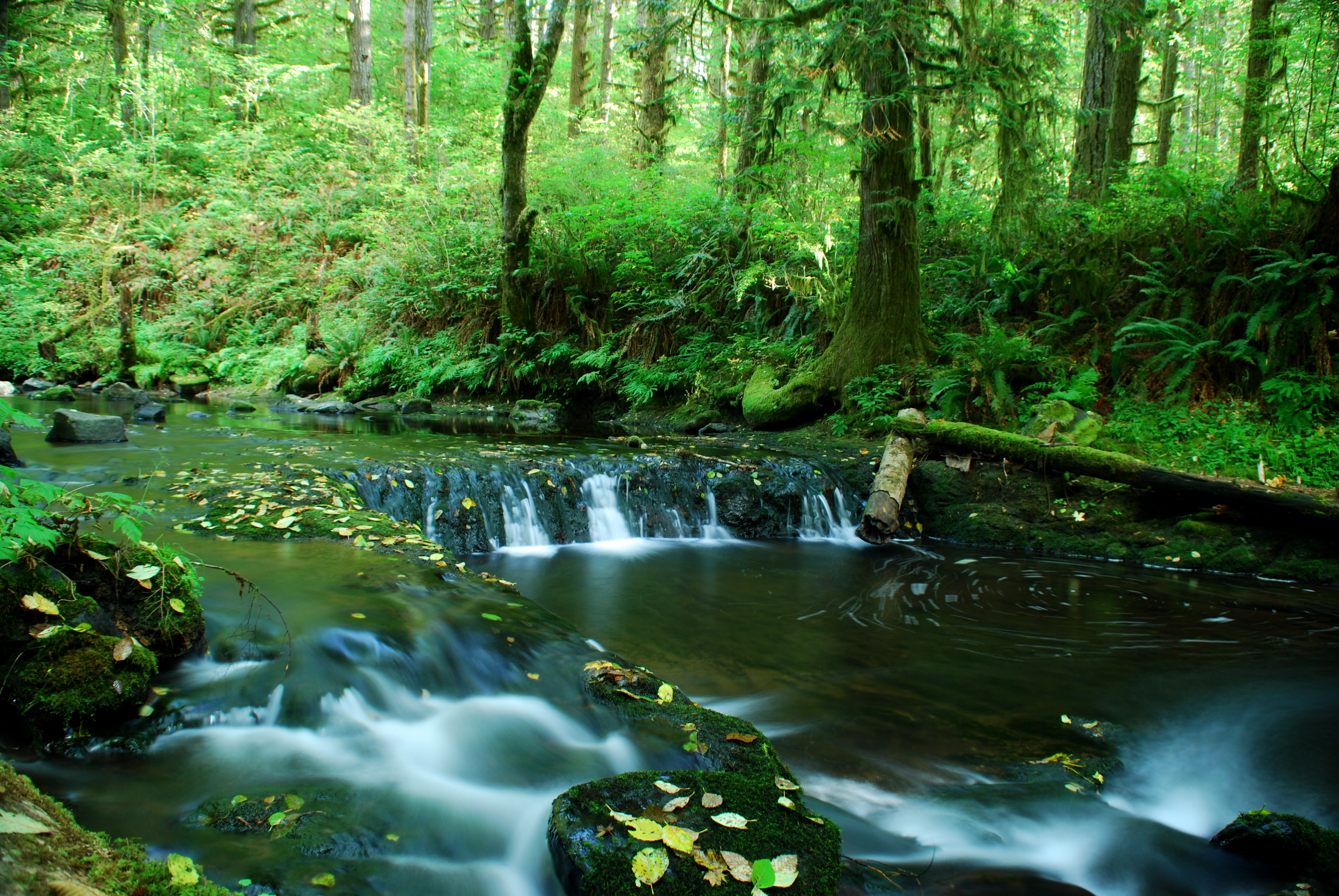
More Shotgun Creek

Royal Terrace, Winter Study

Royal Terrace, Autumn Study

Lower Falls, Winter Study

McDowell Creek, Autumn Study #2

Horse Rock Ridge, Study 2

Horse Rock Ridge, Study 1
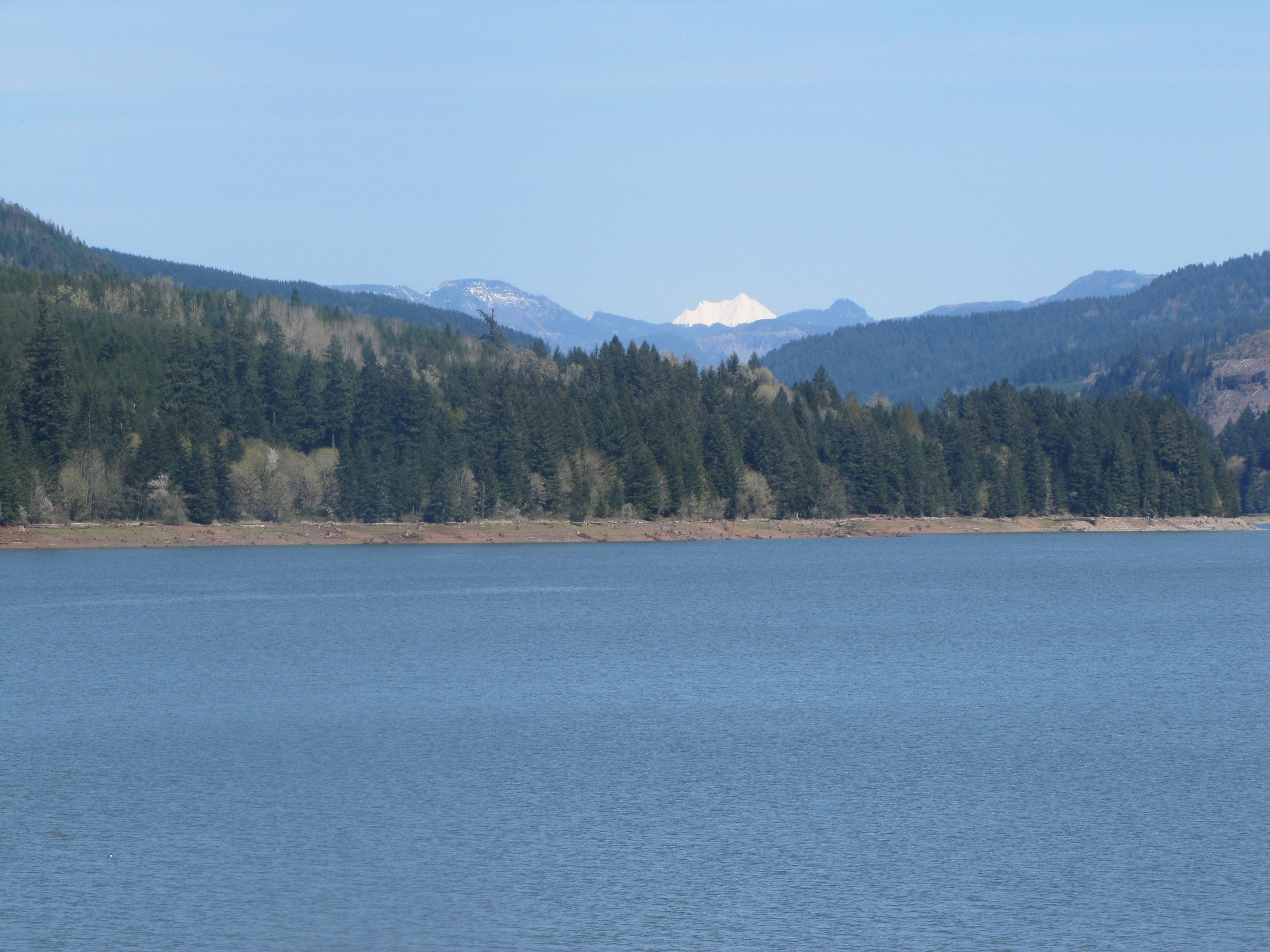
IMG_1406 Snow-covered Mount Jefferson viewed from Foster Dam
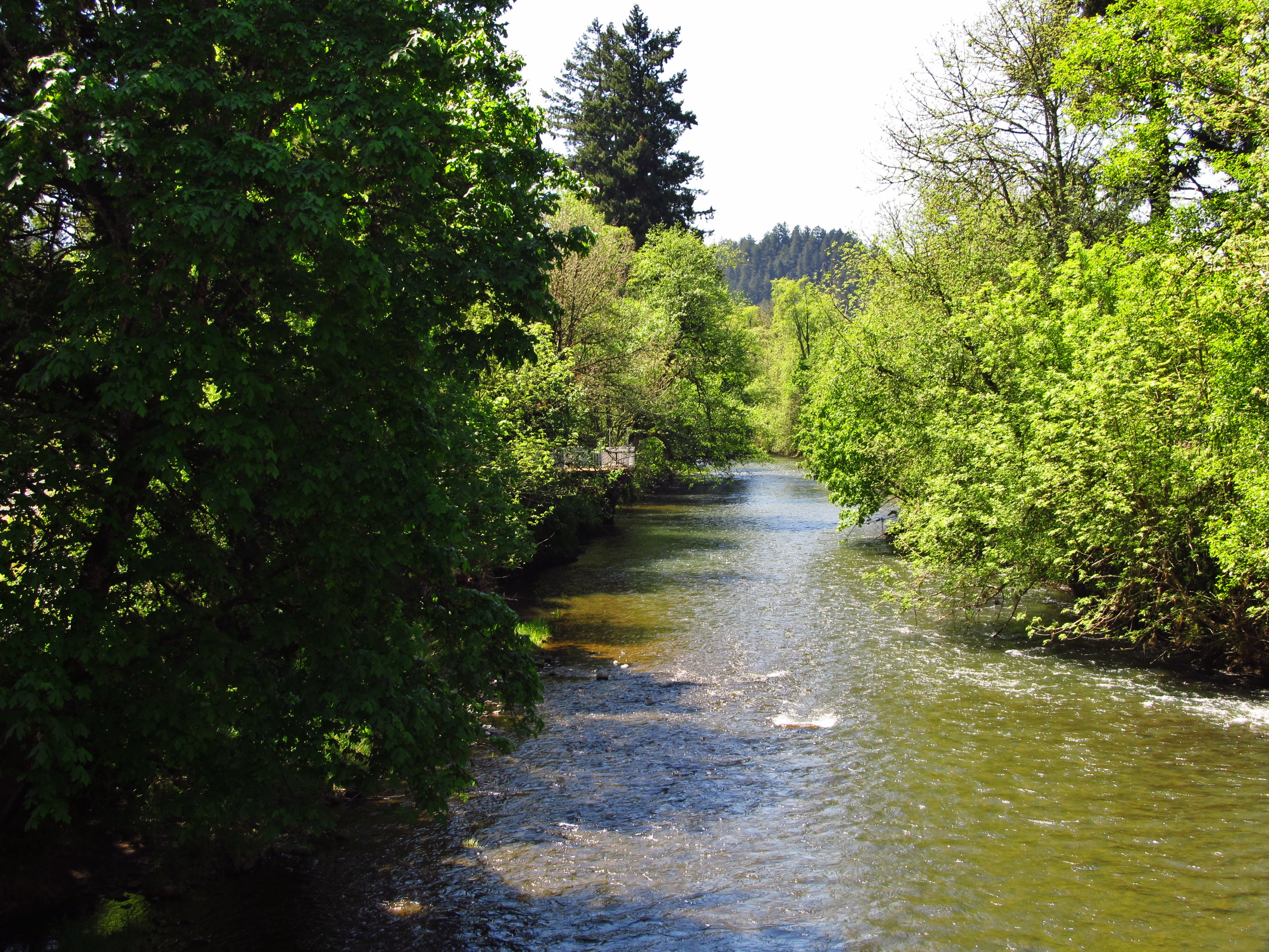
Crawfordsville, Oregon
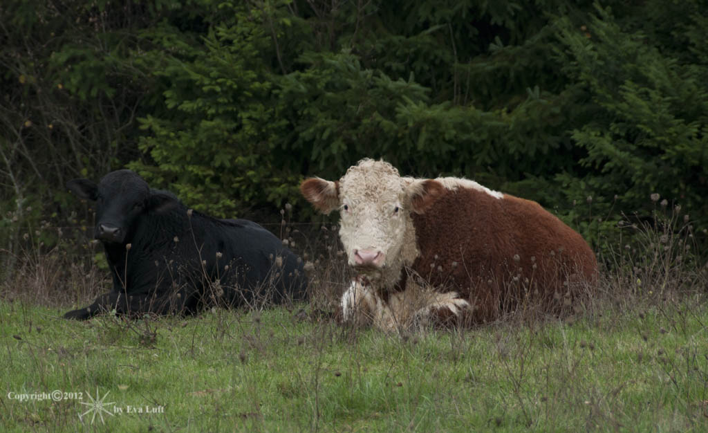
Peaceful-Co-Existence. Image by Eva.
Calapooia, OR 美國的地圖
搜索其他地方的日出日落時間
附近地點
美國俄勒岡霍利
Old Holley Rd, Sweet Home, OR 美國
Oak Terrace, Sweet Home, OR 美國
美國俄勒冈州斯威特霍姆
Strawberry Loop, Sweet Home, OR 美國
Mohawk River Rd, Marcola, OR 美國
Mohawk River Rd, Marcola, OR 美國
Howard Rd, Oregon 美國Howard Road
Marcola Rd, Marcola, OR 美國
Shotgun Creek, Oregon, 美國
Shotgun Creek Rd, Marcola, OR 美國
McDowell Creek Dr, Lebanon, OR 美國
Paschelke Rd, Marcola, OR 美國Earnest Bridge
Marcola Rd, Marcola, OR 美國
Sagebrush SE Dr, Lebanon, OR 美國
Mountain Home Dr, Brownsville, OR 美國
Courtney Creek Dr, Brownsville, OR 美國Courtney Creek Drive
Townsend Rd, Lebanon, OR 美國Townsend Road
美國俄勒岡滑铁卢
Marcola, OR, 美國
最近搜索
- Red Dog Mine, AK, USA的日出日落時間表
- Am bhf, Borken, 德國Am Bahnhof的日出日落時間表
- 4th St E, Sonoma, CA 美國的日出日落時間表
- Oakland Ave, Williamsport, PA 美國的日出日落時間表
- Via Roma, Pieranica CR, 義大利的日出日落時間表
- 克羅埃西亞杜布羅夫尼克 GradClock Tower of Dubrovnik的日出日落時間表
- 阿根廷丘布特省特雷利烏的日出日落時間表
- Hartfords Bluff Cir, Mt Pleasant, SC 美國的日出日落時間表
- 日本熊本縣熊本市北區的日出日落時間表
- 中國福州市平潭縣平潭島的日出日落時間表