Charleston Rd, Leon, WV アメリカ合衆国日の出日の入り時間
Location: アメリカ合衆国 > ウェスト・バージニア州 > メーソン > アメリカ合衆国 ウェスト・バージニア州 コロン > アメリカ合衆国 〒 ウェスト・バージニア州 レオン >
時間帯:
America/New_York
現地時間:
2025-06-25 18:45:56
経度:
-81.948808
緯度:
38.687492
今日の日の出時刻:
06:04:59 AM
今日の日の入時刻:
08:56:39 PM
今日の日長:
14h 51m 40s
明日の日の出時刻:
06:05:22 AM
明日の日の入時刻:
08:56:41 PM
明日の日長:
14h 51m 19s
すべて表示する
| 日付 | 日出 | 日没 | 日長 |
|---|---|---|---|
| 2025年01月01日 | 07:45:50 AM | 05:17:59 PM | 9h 32m 9s |
| 2025年01月02日 | 07:45:55 AM | 05:18:49 PM | 9h 32m 54s |
| 2025年01月03日 | 07:45:58 AM | 05:19:41 PM | 9h 33m 43s |
| 2025年01月04日 | 07:45:58 AM | 05:20:35 PM | 9h 34m 37s |
| 2025年01月05日 | 07:45:56 AM | 05:21:29 PM | 9h 35m 33s |
| 2025年01月06日 | 07:45:52 AM | 05:22:25 PM | 9h 36m 33s |
| 2025年01月07日 | 07:45:46 AM | 05:23:22 PM | 9h 37m 36s |
| 2025年01月08日 | 07:45:38 AM | 05:24:19 PM | 9h 38m 41s |
| 2025年01月09日 | 07:45:28 AM | 05:25:18 PM | 9h 39m 50s |
| 2025年01月10日 | 07:45:15 AM | 05:26:18 PM | 9h 41m 3s |
| 2025年01月11日 | 07:45:01 AM | 05:27:19 PM | 9h 42m 18s |
| 2025年01月12日 | 07:44:44 AM | 05:28:21 PM | 9h 43m 37s |
| 2025年01月13日 | 07:44:25 AM | 05:29:23 PM | 9h 44m 58s |
| 2025年01月14日 | 07:44:05 AM | 05:30:26 PM | 9h 46m 21s |
| 2025年01月15日 | 07:43:42 AM | 05:31:30 PM | 9h 47m 48s |
| 2025年01月16日 | 07:43:17 AM | 05:32:35 PM | 9h 49m 18s |
| 2025年01月17日 | 07:42:50 AM | 05:33:40 PM | 9h 50m 50s |
| 2025年01月18日 | 07:42:21 AM | 05:34:46 PM | 9h 52m 25s |
| 2025年01月19日 | 07:41:50 AM | 05:35:52 PM | 9h 54m 2s |
| 2025年01月20日 | 07:41:17 AM | 05:36:59 PM | 9h 55m 42s |
| 2025年01月21日 | 07:40:42 AM | 05:38:06 PM | 9h 57m 24s |
| 2025年01月22日 | 07:40:06 AM | 05:39:14 PM | 9h 59m 8s |
| 2025年01月23日 | 07:39:27 AM | 05:40:21 PM | 10h 0m 54s |
| 2025年01月24日 | 07:38:46 AM | 05:41:30 PM | 10h 2m 44s |
| 2025年01月25日 | 07:38:04 AM | 05:42:38 PM | 10h 4m 34s |
| 2025年01月26日 | 07:37:20 AM | 05:43:47 PM | 10h 6m 27s |
| 2025年01月27日 | 07:36:34 AM | 05:44:55 PM | 10h 8m 21s |
| 2025年01月28日 | 07:35:46 AM | 05:46:04 PM | 10h 10m 18s |
| 2025年01月29日 | 07:34:57 AM | 05:47:13 PM | 10h 12m 16s |
| 2025年01月30日 | 07:34:05 AM | 05:48:22 PM | 10h 14m 17s |
| 2025年01月31日 | 07:33:12 AM | 05:49:31 PM | 10h 16m 19s |
| 2025年02月01日 | 07:32:18 AM | 05:50:41 PM | 10h 18m 23s |
| 2025年02月02日 | 07:31:22 AM | 05:51:50 PM | 10h 20m 28s |
| 2025年02月03日 | 07:30:24 AM | 05:52:59 PM | 10h 22m 35s |
| 2025年02月04日 | 07:29:25 AM | 05:54:08 PM | 10h 24m 43s |
| 2025年02月05日 | 07:28:24 AM | 05:55:17 PM | 10h 26m 53s |
| 2025年02月06日 | 07:27:22 AM | 05:56:25 PM | 10h 29m 3s |
| 2025年02月07日 | 07:26:19 AM | 05:57:34 PM | 10h 31m 15s |
| 2025年02月08日 | 07:25:14 AM | 05:58:42 PM | 10h 33m 28s |
| 2025年02月09日 | 07:24:07 AM | 05:59:50 PM | 10h 35m 43s |
| 2025年02月10日 | 07:23:00 AM | 06:00:58 PM | 10h 37m 58s |
| 2025年02月11日 | 07:21:51 AM | 06:02:06 PM | 10h 40m 15s |
| 2025年02月12日 | 07:20:40 AM | 06:03:14 PM | 10h 42m 34s |
| 2025年02月13日 | 07:19:29 AM | 06:04:21 PM | 10h 44m 52s |
| 2025年02月14日 | 07:18:16 AM | 06:05:28 PM | 10h 47m 12s |
| 2025年02月15日 | 07:17:02 AM | 06:06:35 PM | 10h 49m 33s |
| 2025年02月16日 | 07:15:47 AM | 06:07:41 PM | 10h 51m 54s |
| 2025年02月17日 | 07:14:31 AM | 06:08:48 PM | 10h 54m 17s |
| 2025年02月18日 | 07:13:14 AM | 06:09:53 PM | 10h 56m 39s |
| 2025年02月19日 | 07:11:56 AM | 06:10:59 PM | 10h 59m 3s |
| 2025年02月20日 | 07:10:37 AM | 06:12:04 PM | 11h 1m 27s |
| 2025年02月21日 | 07:09:17 AM | 06:13:09 PM | 11h 3m 52s |
| 2025年02月22日 | 07:07:56 AM | 06:14:14 PM | 11h 6m 18s |
| 2025年02月23日 | 07:06:34 AM | 06:15:18 PM | 11h 8m 44s |
| 2025年02月24日 | 07:05:11 AM | 06:16:22 PM | 11h 11m 11s |
| 2025年02月25日 | 07:03:47 AM | 06:17:26 PM | 11h 13m 39s |
| 2025年02月26日 | 07:02:23 AM | 06:18:30 PM | 11h 16m 7s |
| 2025年02月27日 | 07:00:58 AM | 06:19:33 PM | 11h 18m 35s |
| 2025年02月28日 | 06:59:32 AM | 06:20:35 PM | 11h 21m 3s |
| 2025年03月01日 | 06:58:05 AM | 06:21:38 PM | 11h 23m 33s |
| 2025年03月02日 | 06:56:38 AM | 06:22:40 PM | 11h 26m 2s |
| 2025年03月03日 | 06:55:10 AM | 06:23:42 PM | 11h 28m 32s |
| 2025年03月04日 | 06:53:41 AM | 06:24:44 PM | 11h 31m 3s |
| 2025年03月05日 | 06:52:12 AM | 06:25:45 PM | 11h 33m 33s |
| 2025年03月06日 | 06:50:43 AM | 06:26:46 PM | 11h 36m 3s |
| 2025年03月07日 | 06:49:13 AM | 06:27:47 PM | 11h 38m 34s |
| 2025年03月08日 | 06:47:42 AM | 06:28:47 PM | 11h 41m 5s |
| 2025年03月09日 | 07:46:15 AM | 07:29:45 PM | 11h 43m 30s |
| 2025年03月10日 | 07:44:44 AM | 07:30:45 PM | 11h 46m 1s |
| 2025年03月11日 | 07:43:12 AM | 07:31:45 PM | 11h 48m 33s |
| 2025年03月12日 | 07:41:40 AM | 07:32:45 PM | 11h 51m 5s |
| 2025年03月13日 | 07:40:07 AM | 07:33:44 PM | 11h 53m 37s |
| 2025年03月14日 | 07:38:35 AM | 07:34:43 PM | 11h 56m 8s |
| 2025年03月15日 | 07:37:02 AM | 07:35:42 PM | 11h 58m 40s |
| 2025年03月16日 | 07:35:29 AM | 07:36:41 PM | 12h 1m 12s |
| 2025年03月17日 | 07:33:55 AM | 07:37:39 PM | 12h 3m 44s |
| 2025年03月18日 | 07:32:22 AM | 07:38:38 PM | 12h 6m 16s |
| 2025年03月19日 | 07:30:48 AM | 07:39:36 PM | 12h 8m 48s |
| 2025年03月20日 | 07:29:14 AM | 07:40:34 PM | 12h 11m 20s |
| 2025年03月21日 | 07:27:41 AM | 07:41:32 PM | 12h 13m 51s |
| 2025年03月22日 | 07:26:07 AM | 07:42:30 PM | 12h 16m 23s |
| 2025年03月23日 | 07:24:33 AM | 07:43:28 PM | 12h 18m 55s |
| 2025年03月24日 | 07:22:59 AM | 07:44:26 PM | 12h 21m 27s |
| 2025年03月25日 | 07:21:25 AM | 07:45:23 PM | 12h 23m 58s |
| 2025年03月26日 | 07:19:52 AM | 07:46:21 PM | 12h 26m 29s |
| 2025年03月27日 | 07:18:18 AM | 07:47:18 PM | 12h 29m 0s |
| 2025年03月28日 | 07:16:45 AM | 07:48:15 PM | 12h 31m 30s |
| 2025年03月29日 | 07:15:11 AM | 07:49:13 PM | 12h 34m 2s |
| 2025年03月30日 | 07:13:38 AM | 07:50:10 PM | 12h 36m 32s |
| 2025年03月31日 | 07:12:05 AM | 07:51:07 PM | 12h 39m 2s |
| 2025年04月01日 | 07:10:33 AM | 07:52:04 PM | 12h 41m 31s |
| 2025年04月02日 | 07:09:00 AM | 07:53:01 PM | 12h 44m 1s |
| 2025年04月03日 | 07:07:29 AM | 07:53:59 PM | 12h 46m 30s |
| 2025年04月04日 | 07:05:57 AM | 07:54:56 PM | 12h 48m 59s |
| 2025年04月05日 | 07:04:26 AM | 07:55:53 PM | 12h 51m 27s |
| 2025年04月06日 | 07:02:55 AM | 07:56:50 PM | 12h 53m 55s |
| 2025年04月07日 | 07:01:24 AM | 07:57:47 PM | 12h 56m 23s |
| 2025年04月08日 | 06:59:54 AM | 07:58:44 PM | 12h 58m 50s |
| 2025年04月09日 | 06:58:25 AM | 07:59:42 PM | 13h 1m 17s |
| 2025年04月10日 | 06:56:56 AM | 08:00:39 PM | 13h 3m 43s |
| 2025年04月11日 | 06:55:28 AM | 08:01:36 PM | 13h 6m 8s |
| 2025年04月12日 | 06:54:00 AM | 08:02:33 PM | 13h 8m 33s |
| 2025年04月13日 | 06:52:33 AM | 08:03:31 PM | 13h 10m 58s |
| 2025年04月14日 | 06:51:07 AM | 08:04:28 PM | 13h 13m 21s |
| 2025年04月15日 | 06:49:41 AM | 08:05:26 PM | 13h 15m 45s |
| 2025年04月16日 | 06:48:16 AM | 08:06:23 PM | 13h 18m 7s |
| 2025年04月17日 | 06:46:51 AM | 08:07:20 PM | 13h 20m 29s |
| 2025年04月18日 | 06:45:28 AM | 08:08:18 PM | 13h 22m 50s |
| 2025年04月19日 | 06:44:05 AM | 08:09:15 PM | 13h 25m 10s |
| 2025年04月20日 | 06:42:43 AM | 08:10:13 PM | 13h 27m 30s |
| 2025年04月21日 | 06:41:22 AM | 08:11:11 PM | 13h 29m 49s |
| 2025年04月22日 | 06:40:02 AM | 08:12:08 PM | 13h 32m 6s |
| 2025年04月23日 | 06:38:43 AM | 08:13:06 PM | 13h 34m 23s |
| 2025年04月24日 | 06:37:25 AM | 08:14:03 PM | 13h 36m 38s |
| 2025年04月25日 | 06:36:07 AM | 08:15:01 PM | 13h 38m 54s |
| 2025年04月26日 | 06:34:51 AM | 08:15:58 PM | 13h 41m 7s |
| 2025年04月27日 | 06:33:36 AM | 08:16:56 PM | 13h 43m 20s |
| 2025年04月28日 | 06:32:22 AM | 08:17:53 PM | 13h 45m 31s |
| 2025年04月29日 | 06:31:09 AM | 08:18:51 PM | 13h 47m 42s |
| 2025年04月30日 | 06:29:57 AM | 08:19:48 PM | 13h 49m 51s |
| 2025年05月01日 | 06:28:46 AM | 08:20:45 PM | 13h 51m 59s |
| 2025年05月02日 | 06:27:37 AM | 08:21:42 PM | 13h 54m 5s |
| 2025年05月03日 | 06:26:29 AM | 08:22:39 PM | 13h 56m 10s |
| 2025年05月04日 | 06:25:22 AM | 08:23:36 PM | 13h 58m 14s |
| 2025年05月05日 | 06:24:16 AM | 08:24:33 PM | 14h 0m 17s |
| 2025年05月06日 | 06:23:12 AM | 08:25:29 PM | 14h 2m 17s |
| 2025年05月07日 | 06:22:09 AM | 08:26:25 PM | 14h 4m 16s |
| 2025年05月08日 | 06:21:07 AM | 08:27:21 PM | 14h 6m 14s |
| 2025年05月09日 | 06:20:07 AM | 08:28:17 PM | 14h 8m 10s |
| 2025年05月10日 | 06:19:08 AM | 08:29:13 PM | 14h 10m 5s |
| 2025年05月11日 | 06:18:10 AM | 08:30:08 PM | 14h 11m 58s |
| 2025年05月12日 | 06:17:15 AM | 08:31:03 PM | 14h 13m 48s |
| 2025年05月13日 | 06:16:20 AM | 08:31:57 PM | 14h 15m 37s |
| 2025年05月14日 | 06:15:27 AM | 08:32:51 PM | 14h 17m 24s |
| 2025年05月15日 | 06:14:36 AM | 08:33:45 PM | 14h 19m 9s |
| 2025年05月16日 | 06:13:46 AM | 08:34:38 PM | 14h 20m 52s |
| 2025年05月17日 | 06:12:58 AM | 08:35:31 PM | 14h 22m 33s |
| 2025年05月18日 | 06:12:12 AM | 08:36:23 PM | 14h 24m 11s |
| 2025年05月19日 | 06:11:27 AM | 08:37:14 PM | 14h 25m 47s |
| 2025年05月20日 | 06:10:44 AM | 08:38:05 PM | 14h 27m 21s |
| 2025年05月21日 | 06:10:03 AM | 08:38:56 PM | 14h 28m 53s |
| 2025年05月22日 | 06:09:23 AM | 08:39:45 PM | 14h 30m 22s |
| 2025年05月23日 | 06:08:45 AM | 08:40:34 PM | 14h 31m 49s |
| 2025年05月24日 | 06:08:09 AM | 08:41:22 PM | 14h 33m 13s |
| 2025年05月25日 | 06:07:34 AM | 08:42:10 PM | 14h 34m 36s |
| 2025年05月26日 | 06:07:02 AM | 08:42:56 PM | 14h 35m 54s |
| 2025年05月27日 | 06:06:31 AM | 08:43:42 PM | 14h 37m 11s |
| 2025年05月28日 | 06:06:02 AM | 08:44:27 PM | 14h 38m 25s |
| 2025年05月29日 | 06:05:34 AM | 08:45:11 PM | 14h 39m 37s |
| 2025年05月30日 | 06:05:09 AM | 08:45:54 PM | 14h 40m 45s |
| 2025年05月31日 | 06:04:45 AM | 08:46:35 PM | 14h 41m 50s |
| 2025年06月01日 | 06:04:24 AM | 08:47:16 PM | 14h 42m 52s |
| 2025年06月02日 | 06:04:04 AM | 08:47:56 PM | 14h 43m 52s |
| 2025年06月03日 | 06:03:46 AM | 08:48:34 PM | 14h 44m 48s |
| 2025年06月04日 | 06:03:30 AM | 08:49:12 PM | 14h 45m 42s |
| 2025年06月05日 | 06:03:15 AM | 08:49:48 PM | 14h 46m 33s |
| 2025年06月06日 | 06:03:03 AM | 08:50:23 PM | 14h 47m 20s |
| 2025年06月07日 | 06:02:52 AM | 08:50:56 PM | 14h 48m 4s |
| 2025年06月08日 | 06:02:43 AM | 08:51:28 PM | 14h 48m 45s |
| 2025年06月09日 | 06:02:37 AM | 08:51:59 PM | 14h 49m 22s |
| 2025年06月10日 | 06:02:32 AM | 08:52:28 PM | 14h 49m 56s |
| 2025年06月11日 | 06:02:28 AM | 08:52:56 PM | 14h 50m 28s |
| 2025年06月12日 | 06:02:27 AM | 08:53:23 PM | 14h 50m 56s |
| 2025年06月13日 | 06:02:28 AM | 08:53:48 PM | 14h 51m 20s |
| 2025年06月14日 | 06:02:30 AM | 08:54:11 PM | 14h 51m 41s |
| 2025年06月15日 | 06:02:34 AM | 08:54:33 PM | 14h 51m 59s |
| 2025年06月16日 | 06:02:40 AM | 08:54:53 PM | 14h 52m 13s |
| 2025年06月17日 | 06:02:47 AM | 08:55:11 PM | 14h 52m 24s |
| 2025年06月18日 | 06:02:57 AM | 08:55:28 PM | 14h 52m 31s |
| 2025年06月19日 | 06:03:08 AM | 08:55:43 PM | 14h 52m 35s |
| 2025年06月20日 | 06:03:20 AM | 08:55:57 PM | 14h 52m 37s |
| 2025年06月21日 | 06:03:35 AM | 08:56:08 PM | 14h 52m 33s |
| 2025年06月22日 | 06:03:51 AM | 08:56:18 PM | 14h 52m 27s |
| 2025年06月23日 | 06:04:08 AM | 08:56:27 PM | 14h 52m 19s |
| 2025年06月24日 | 06:04:28 AM | 08:56:33 PM | 14h 52m 5s |
| 2025年06月25日 | 06:04:48 AM | 08:56:37 PM | 14h 51m 49s |
| 2025年06月26日 | 06:05:11 AM | 08:56:40 PM | 14h 51m 29s |
| 2025年06月27日 | 06:05:35 AM | 08:56:41 PM | 14h 51m 6s |
| 2025年06月28日 | 06:06:00 AM | 08:56:40 PM | 14h 50m 40s |
| 2025年06月29日 | 06:06:27 AM | 08:56:37 PM | 14h 50m 10s |
| 2025年06月30日 | 06:06:55 AM | 08:56:32 PM | 14h 49m 37s |
| 2025年07月01日 | 06:07:24 AM | 08:56:25 PM | 14h 49m 1s |
| 2025年07月02日 | 06:07:55 AM | 08:56:17 PM | 14h 48m 22s |
| 2025年07月03日 | 06:08:27 AM | 08:56:06 PM | 14h 47m 39s |
| 2025年07月04日 | 06:09:00 AM | 08:55:54 PM | 14h 46m 54s |
| 2025年07月05日 | 06:09:35 AM | 08:55:39 PM | 14h 46m 4s |
| 2025年07月06日 | 06:10:10 AM | 08:55:23 PM | 14h 45m 13s |
| 2025年07月07日 | 06:10:47 AM | 08:55:05 PM | 14h 44m 18s |
| 2025年07月08日 | 06:11:25 AM | 08:54:45 PM | 14h 43m 20s |
| 2025年07月09日 | 06:12:04 AM | 08:54:23 PM | 14h 42m 19s |
| 2025年07月10日 | 06:12:44 AM | 08:53:59 PM | 14h 41m 15s |
| 2025年07月11日 | 06:13:25 AM | 08:53:33 PM | 14h 40m 8s |
| 2025年07月12日 | 06:14:07 AM | 08:53:06 PM | 14h 38m 59s |
| 2025年07月13日 | 06:14:49 AM | 08:52:36 PM | 14h 37m 47s |
| 2025年07月14日 | 06:15:33 AM | 08:52:05 PM | 14h 36m 32s |
| 2025年07月15日 | 06:16:17 AM | 08:51:32 PM | 14h 35m 15s |
| 2025年07月16日 | 06:17:02 AM | 08:50:57 PM | 14h 33m 55s |
| 2025年07月17日 | 06:17:48 AM | 08:50:21 PM | 14h 32m 33s |
| 2025年07月18日 | 06:18:35 AM | 08:49:42 PM | 14h 31m 7s |
| 2025年07月19日 | 06:19:22 AM | 08:49:02 PM | 14h 29m 40s |
| 2025年07月20日 | 06:20:10 AM | 08:48:20 PM | 14h 28m 10s |
| 2025年07月21日 | 06:20:58 AM | 08:47:36 PM | 14h 26m 38s |
| 2025年07月22日 | 06:21:47 AM | 08:46:51 PM | 14h 25m 4s |
| 2025年07月23日 | 06:22:37 AM | 08:46:04 PM | 14h 23m 27s |
| 2025年07月24日 | 06:23:27 AM | 08:45:15 PM | 14h 21m 48s |
| 2025年07月25日 | 06:24:17 AM | 08:44:25 PM | 14h 20m 8s |
| 2025年07月26日 | 06:25:08 AM | 08:43:33 PM | 14h 18m 25s |
| 2025年07月27日 | 06:25:59 AM | 08:42:39 PM | 14h 16m 40s |
| 2025年07月28日 | 06:26:51 AM | 08:41:44 PM | 14h 14m 53s |
| 2025年07月29日 | 06:27:43 AM | 08:40:47 PM | 14h 13m 4s |
| 2025年07月30日 | 06:28:35 AM | 08:39:49 PM | 14h 11m 14s |
| 2025年07月31日 | 06:29:27 AM | 08:38:49 PM | 14h 9m 22s |
| 2025年08月01日 | 06:30:20 AM | 08:37:48 PM | 14h 7m 28s |
| 2025年08月02日 | 06:31:13 AM | 08:36:46 PM | 14h 5m 33s |
| 2025年08月03日 | 06:32:06 AM | 08:35:42 PM | 14h 3m 36s |
| 2025年08月04日 | 06:32:59 AM | 08:34:36 PM | 14h 1m 37s |
| 2025年08月05日 | 06:33:53 AM | 08:33:30 PM | 13h 59m 37s |
| 2025年08月06日 | 06:34:46 AM | 08:32:22 PM | 13h 57m 36s |
| 2025年08月07日 | 06:35:40 AM | 08:31:12 PM | 13h 55m 32s |
| 2025年08月08日 | 06:36:34 AM | 08:30:02 PM | 13h 53m 28s |
| 2025年08月09日 | 06:37:27 AM | 08:28:50 PM | 13h 51m 23s |
| 2025年08月10日 | 06:38:21 AM | 08:27:37 PM | 13h 49m 16s |
| 2025年08月11日 | 06:39:15 AM | 08:26:23 PM | 13h 47m 8s |
| 2025年08月12日 | 06:40:09 AM | 08:25:08 PM | 13h 44m 59s |
| 2025年08月13日 | 06:41:03 AM | 08:23:52 PM | 13h 42m 49s |
| 2025年08月14日 | 06:41:57 AM | 08:22:34 PM | 13h 40m 37s |
| 2025年08月15日 | 06:42:51 AM | 08:21:16 PM | 13h 38m 25s |
| 2025年08月16日 | 06:43:44 AM | 08:19:56 PM | 13h 36m 12s |
| 2025年08月17日 | 06:44:38 AM | 08:18:36 PM | 13h 33m 58s |
| 2025年08月18日 | 06:45:32 AM | 08:17:15 PM | 13h 31m 43s |
| 2025年08月19日 | 06:46:26 AM | 08:15:52 PM | 13h 29m 26s |
| 2025年08月20日 | 06:47:19 AM | 08:14:29 PM | 13h 27m 10s |
| 2025年08月21日 | 06:48:13 AM | 08:13:05 PM | 13h 24m 52s |
| 2025年08月22日 | 06:49:07 AM | 08:11:40 PM | 13h 22m 33s |
| 2025年08月23日 | 06:50:00 AM | 08:10:14 PM | 13h 20m 14s |
| 2025年08月24日 | 06:50:54 AM | 08:08:48 PM | 13h 17m 54s |
| 2025年08月25日 | 06:51:47 AM | 08:07:21 PM | 13h 15m 34s |
| 2025年08月26日 | 06:52:40 AM | 08:05:53 PM | 13h 13m 13s |
| 2025年08月27日 | 06:53:34 AM | 08:04:24 PM | 13h 10m 50s |
| 2025年08月28日 | 06:54:27 AM | 08:02:55 PM | 13h 8m 28s |
| 2025年08月29日 | 06:55:20 AM | 08:01:25 PM | 13h 6m 5s |
| 2025年08月30日 | 06:56:13 AM | 07:59:55 PM | 13h 3m 42s |
| 2025年08月31日 | 06:57:06 AM | 07:58:24 PM | 13h 1m 18s |
| 2025年09月01日 | 06:57:59 AM | 07:56:52 PM | 12h 58m 53s |
| 2025年09月02日 | 06:58:52 AM | 07:55:20 PM | 12h 56m 28s |
| 2025年09月03日 | 06:59:45 AM | 07:53:48 PM | 12h 54m 3s |
| 2025年09月04日 | 07:00:38 AM | 07:52:15 PM | 12h 51m 37s |
| 2025年09月05日 | 07:01:30 AM | 07:50:41 PM | 12h 49m 11s |
| 2025年09月06日 | 07:02:23 AM | 07:49:08 PM | 12h 46m 45s |
| 2025年09月07日 | 07:03:16 AM | 07:47:33 PM | 12h 44m 17s |
| 2025年09月08日 | 07:04:09 AM | 07:45:59 PM | 12h 41m 50s |
| 2025年09月09日 | 07:05:01 AM | 07:44:24 PM | 12h 39m 23s |
| 2025年09月10日 | 07:05:54 AM | 07:42:49 PM | 12h 36m 55s |
| 2025年09月11日 | 07:06:47 AM | 07:41:14 PM | 12h 34m 27s |
| 2025年09月12日 | 07:07:40 AM | 07:39:39 PM | 12h 31m 59s |
| 2025年09月13日 | 07:08:33 AM | 07:38:03 PM | 12h 29m 30s |
| 2025年09月14日 | 07:09:26 AM | 07:36:27 PM | 12h 27m 1s |
| 2025年09月15日 | 07:10:19 AM | 07:34:51 PM | 12h 24m 32s |
| 2025年09月16日 | 07:11:12 AM | 07:33:16 PM | 12h 22m 4s |
| 2025年09月17日 | 07:12:05 AM | 07:31:40 PM | 12h 19m 35s |
| 2025年09月18日 | 07:12:58 AM | 07:30:03 PM | 12h 17m 5s |
| 2025年09月19日 | 07:13:51 AM | 07:28:27 PM | 12h 14m 36s |
| 2025年09月20日 | 07:14:45 AM | 07:26:51 PM | 12h 12m 6s |
| 2025年09月21日 | 07:15:38 AM | 07:25:15 PM | 12h 9m 37s |
| 2025年09月22日 | 07:16:32 AM | 07:23:40 PM | 12h 7m 8s |
| 2025年09月23日 | 07:17:26 AM | 07:22:04 PM | 12h 4m 38s |
| 2025年09月24日 | 07:18:20 AM | 07:20:28 PM | 12h 2m 8s |
| 2025年09月25日 | 07:19:14 AM | 07:18:53 PM | 11h 59m 39s |
| 2025年09月26日 | 07:20:08 AM | 07:17:18 PM | 11h 57m 10s |
| 2025年09月27日 | 07:21:03 AM | 07:15:43 PM | 11h 54m 40s |
| 2025年09月28日 | 07:21:58 AM | 07:14:08 PM | 11h 52m 10s |
| 2025年09月29日 | 07:22:53 AM | 07:12:33 PM | 11h 49m 40s |
| 2025年09月30日 | 07:23:48 AM | 07:10:59 PM | 11h 47m 11s |
| 2025年10月01日 | 07:24:43 AM | 07:09:26 PM | 11h 44m 43s |
| 2025年10月02日 | 07:25:39 AM | 07:07:52 PM | 11h 42m 13s |
| 2025年10月03日 | 07:26:35 AM | 07:06:19 PM | 11h 39m 44s |
| 2025年10月04日 | 07:27:31 AM | 07:04:47 PM | 11h 37m 16s |
| 2025年10月05日 | 07:28:28 AM | 07:03:15 PM | 11h 34m 47s |
| 2025年10月06日 | 07:29:25 AM | 07:01:43 PM | 11h 32m 18s |
| 2025年10月07日 | 07:30:22 AM | 07:00:12 PM | 11h 29m 50s |
| 2025年10月08日 | 07:31:19 AM | 06:58:42 PM | 11h 27m 23s |
| 2025年10月09日 | 07:32:17 AM | 06:57:12 PM | 11h 24m 55s |
| 2025年10月10日 | 07:33:15 AM | 06:55:43 PM | 11h 22m 28s |
| 2025年10月11日 | 07:34:13 AM | 06:54:15 PM | 11h 20m 2s |
| 2025年10月12日 | 07:35:12 AM | 06:52:47 PM | 11h 17m 35s |
| 2025年10月13日 | 07:36:10 AM | 06:51:20 PM | 11h 15m 10s |
| 2025年10月14日 | 07:37:10 AM | 06:49:54 PM | 11h 12m 44s |
| 2025年10月15日 | 07:38:09 AM | 06:48:28 PM | 11h 10m 19s |
| 2025年10月16日 | 07:39:09 AM | 06:47:03 PM | 11h 7m 54s |
| 2025年10月17日 | 07:40:10 AM | 06:45:40 PM | 11h 5m 30s |
| 2025年10月18日 | 07:41:10 AM | 06:44:17 PM | 11h 3m 7s |
| 2025年10月19日 | 07:42:11 AM | 06:42:55 PM | 11h 0m 44s |
| 2025年10月20日 | 07:43:13 AM | 06:41:34 PM | 10h 58m 21s |
| 2025年10月21日 | 07:44:14 AM | 06:40:14 PM | 10h 56m 0s |
| 2025年10月22日 | 07:45:16 AM | 06:38:55 PM | 10h 53m 39s |
| 2025年10月23日 | 07:46:18 AM | 06:37:37 PM | 10h 51m 19s |
| 2025年10月24日 | 07:47:21 AM | 06:36:20 PM | 10h 48m 59s |
| 2025年10月25日 | 07:48:24 AM | 06:35:04 PM | 10h 46m 40s |
| 2025年10月26日 | 07:49:27 AM | 06:33:50 PM | 10h 44m 23s |
| 2025年10月27日 | 07:50:31 AM | 06:32:36 PM | 10h 42m 5s |
| 2025年10月28日 | 07:51:35 AM | 06:31:24 PM | 10h 39m 49s |
| 2025年10月29日 | 07:52:39 AM | 06:30:14 PM | 10h 37m 35s |
| 2025年10月30日 | 07:53:43 AM | 06:29:04 PM | 10h 35m 21s |
| 2025年10月31日 | 07:54:48 AM | 06:27:56 PM | 10h 33m 8s |
| 2025年11月01日 | 07:55:53 AM | 06:26:49 PM | 10h 30m 56s |
| 2025年11月02日 | 06:57:00 AM | 05:25:41 PM | 10h 28m 41s |
| 2025年11月03日 | 06:58:06 AM | 05:24:37 PM | 10h 26m 31s |
| 2025年11月04日 | 06:59:11 AM | 05:23:35 PM | 10h 24m 24s |
| 2025年11月05日 | 07:00:17 AM | 05:22:34 PM | 10h 22m 17s |
| 2025年11月06日 | 07:01:22 AM | 05:21:34 PM | 10h 20m 12s |
| 2025年11月07日 | 07:02:28 AM | 05:20:37 PM | 10h 18m 9s |
| 2025年11月08日 | 07:03:34 AM | 05:19:40 PM | 10h 16m 6s |
| 2025年11月09日 | 07:04:40 AM | 05:18:46 PM | 10h 14m 6s |
| 2025年11月10日 | 07:05:46 AM | 05:17:53 PM | 10h 12m 7s |
| 2025年11月11日 | 07:06:52 AM | 05:17:02 PM | 10h 10m 10s |
| 2025年11月12日 | 07:07:58 AM | 05:16:12 PM | 10h 8m 14s |
| 2025年11月13日 | 07:09:04 AM | 05:15:25 PM | 10h 6m 21s |
| 2025年11月14日 | 07:10:10 AM | 05:14:39 PM | 10h 4m 29s |
| 2025年11月15日 | 07:11:16 AM | 05:13:55 PM | 10h 2m 39s |
| 2025年11月16日 | 07:12:21 AM | 05:13:12 PM | 10h 0m 51s |
| 2025年11月17日 | 07:13:26 AM | 05:12:32 PM | 9h 59m 6s |
| 2025年11月18日 | 07:14:31 AM | 05:11:54 PM | 9h 57m 23s |
| 2025年11月19日 | 07:15:36 AM | 05:11:17 PM | 9h 55m 41s |
| 2025年11月20日 | 07:16:40 AM | 05:10:43 PM | 9h 54m 3s |
| 2025年11月21日 | 07:17:44 AM | 05:10:10 PM | 9h 52m 26s |
| 2025年11月22日 | 07:18:48 AM | 05:09:40 PM | 9h 50m 52s |
| 2025年11月23日 | 07:19:51 AM | 05:09:11 PM | 9h 49m 20s |
| 2025年11月24日 | 07:20:53 AM | 05:08:45 PM | 9h 47m 52s |
| 2025年11月25日 | 07:21:55 AM | 05:08:20 PM | 9h 46m 25s |
| 2025年11月26日 | 07:22:57 AM | 05:07:58 PM | 9h 45m 1s |
| 2025年11月27日 | 07:23:57 AM | 05:07:38 PM | 9h 43m 41s |
| 2025年11月28日 | 07:24:57 AM | 05:07:20 PM | 9h 42m 23s |
| 2025年11月29日 | 07:25:56 AM | 05:07:04 PM | 9h 41m 8s |
| 2025年11月30日 | 07:26:55 AM | 05:06:50 PM | 9h 39m 55s |
| 2025年12月01日 | 07:27:52 AM | 05:06:39 PM | 9h 38m 47s |
| 2025年12月02日 | 07:28:49 AM | 05:06:29 PM | 9h 37m 40s |
| 2025年12月03日 | 07:29:44 AM | 05:06:22 PM | 9h 36m 38s |
| 2025年12月04日 | 07:30:39 AM | 05:06:17 PM | 9h 35m 38s |
| 2025年12月05日 | 07:31:32 AM | 05:06:14 PM | 9h 34m 42s |
| 2025年12月06日 | 07:32:24 AM | 05:06:13 PM | 9h 33m 49s |
| 2025年12月07日 | 07:33:15 AM | 05:06:15 PM | 9h 33m 0s |
| 2025年12月08日 | 07:34:05 AM | 05:06:18 PM | 9h 32m 13s |
| 2025年12月09日 | 07:34:54 AM | 05:06:24 PM | 9h 31m 30s |
| 2025年12月10日 | 07:35:41 AM | 05:06:32 PM | 9h 30m 51s |
| 2025年12月11日 | 07:36:26 AM | 05:06:42 PM | 9h 30m 16s |
| 2025年12月12日 | 07:37:11 AM | 05:06:54 PM | 9h 29m 43s |
| 2025年12月13日 | 07:37:54 AM | 05:07:08 PM | 9h 29m 14s |
| 2025年12月14日 | 07:38:35 AM | 05:07:25 PM | 9h 28m 50s |
| 2025年12月15日 | 07:39:14 AM | 05:07:43 PM | 9h 28m 29s |
| 2025年12月16日 | 07:39:52 AM | 05:08:04 PM | 9h 28m 12s |
| 2025年12月17日 | 07:40:29 AM | 05:08:26 PM | 9h 27m 57s |
| 2025年12月18日 | 07:41:03 AM | 05:08:51 PM | 9h 27m 48s |
| 2025年12月19日 | 07:41:36 AM | 05:09:17 PM | 9h 27m 41s |
| 2025年12月20日 | 07:42:07 AM | 05:09:46 PM | 9h 27m 39s |
| 2025年12月21日 | 07:42:37 AM | 05:10:16 PM | 9h 27m 39s |
| 2025年12月22日 | 07:43:04 AM | 05:10:49 PM | 9h 27m 45s |
| 2025年12月23日 | 07:43:29 AM | 05:11:23 PM | 9h 27m 54s |
| 2025年12月24日 | 07:43:53 AM | 05:11:59 PM | 9h 28m 6s |
| 2025年12月25日 | 07:44:15 AM | 05:12:36 PM | 9h 28m 21s |
| 2025年12月26日 | 07:44:34 AM | 05:13:16 PM | 9h 28m 42s |
| 2025年12月27日 | 07:44:52 AM | 05:13:57 PM | 9h 29m 5s |
| 2025年12月28日 | 07:45:07 AM | 05:14:40 PM | 9h 29m 33s |
| 2025年12月29日 | 07:45:21 AM | 05:15:24 PM | 9h 30m 3s |
| 2025年12月30日 | 07:45:32 AM | 05:16:10 PM | 9h 30m 38s |
| 2025年12月31日 | 07:45:42 AM | 05:16:58 PM | 9h 31m 16s |
写真

Westward bound...

Remember me to the people of the Allegheny Plateau. Recall that I was here taking pictures of the region's small rivers on sunny winter days.
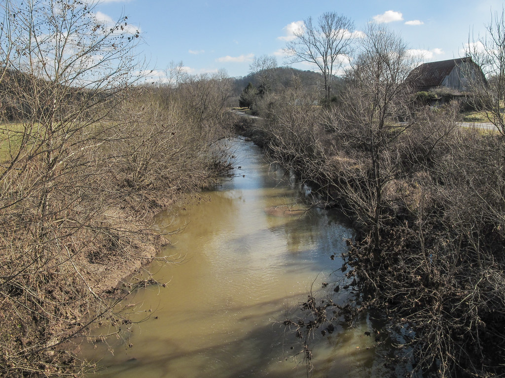
One look and you'll know why it's called Eighteenmile Creek.

Along the West Virginia Secondary

West Virginia Railroading
Charleston Rd, Leon, WV アメリカ合衆国の地図
別の場所を検索
近所の場所
Charleston Rd, Leon, WV アメリカ合衆国
アメリカ合衆国 〒 ウェスト・バージニア州 サウスサイド
アメリカ合衆国 〒 ウェスト・バージニア州 レオン
Tribble Rd, Leon, WV アメリカ合衆国
Cabin Ridge Rd, Leon, WV アメリカ合衆国Cloverdale School (historical)
アメリカ合衆国 ウェスト・バージニア州 バッファロー
アメリカ合衆国 ウェスト・バージニア州 メーソン
アメリカ合衆国 ウェスト・バージニア州 アーバックル
Railroad Ave, Buffalo, WV アメリカ合衆国
アメリカ合衆国 ウェスト・バージニア州 コロン
Nash Ln, Buffalo, WV アメリカ合衆国
Hale Ln, Leon, WV アメリカ合衆国
Tribble Rd, Leon, WV アメリカ合衆国
アメリカ合衆国 ウェスト・バージニア州 バッファロー=ユニオン
アメリカ合衆国 ウェスト・バージニア州 ユニオン
Debbie Rd, Cooper, WV アメリカ合衆国デビー・ロード
Fir St, Eleanor, WV, アメリカ合衆国ファー・ストリート
28 Hemlock St, Eleanor, WV アメリカ合衆国
アメリカ合衆国 ウェスト・バージニア州 エレナー
アメリカ合衆国 ウェスト・バージニア州 レッド・ハウス
最近の検索
- アメリカ合衆国 アラスカ州 レッド・ドッグ・マイン日の出日の入り時間
- Am bhf, Borken, ドイツアム・バーンホーフ日の出日の入り時間
- 4th St E, Sonoma, CA, USA日の出日の入り時間
- Oakland Ave, Williamsport, PA アメリカ合衆国日の出日の入り時間
- Via Roma, Pieranica CR, イタリアローマ通り日の出日の入り時間
- クロアチア 〒 ドゥブロブニク GradClock Tower of Dubrovnik日の出日の入り時間
- アルゼンチン チュブ州 トレリュー日の出日の入り時間
- Hartfords Bluff Cir, Mt Pleasant, SC アメリカ合衆国日の出日の入り時間
- 日本、熊本県熊本市北区日の出日の入り時間
- 中華人民共和国 福州市 平潭県 平潭島日の出日の入り時間