Horas de salida y puesta de sol de Ulba, Ecuador
Location: Ecuador > Tungurahua > Cantón Baños >
Zona horaria:
America/Guayaquil
Hora local:
2024-04-19 04:46:29
Longitud:
-78.3941767
Latitud:
-1.3962203
Salida de sol de hoy:
06:10:11 AM
Puesta de sol de hoy:
06:14:50 PM
La duración del día hoy:
12h 4m 39s
Salida de sol de mañana:
06:10:01 AM
Puesta de sol de mañana:
06:14:36 PM
La duración del día mañana:
12h 4m 35s
Mostrar todas las fechas
| Fecha | Salida de sol | Puesta de sol | Duración del día |
|---|---|---|---|
| 01/01/2024 | 06:11:16 AM | 06:23:25 PM | 12h 12m 9s |
| 02/01/2024 | 06:11:44 AM | 06:23:52 PM | 12h 12m 8s |
| 03/01/2024 | 06:12:13 AM | 06:24:19 PM | 12h 12m 6s |
| 04/01/2024 | 06:12:41 AM | 06:24:45 PM | 12h 12m 4s |
| 05/01/2024 | 06:13:08 AM | 06:25:11 PM | 12h 12m 3s |
| 06/01/2024 | 06:13:36 AM | 06:25:36 PM | 12h 12m 0s |
| 07/01/2024 | 06:14:02 AM | 06:26:00 PM | 12h 11m 58s |
| 08/01/2024 | 06:14:29 AM | 06:26:25 PM | 12h 11m 56s |
| 09/01/2024 | 06:14:55 AM | 06:26:48 PM | 12h 11m 53s |
| 10/01/2024 | 06:15:20 AM | 06:27:11 PM | 12h 11m 51s |
| 11/01/2024 | 06:15:45 AM | 06:27:33 PM | 12h 11m 48s |
| 12/01/2024 | 06:16:10 AM | 06:27:55 PM | 12h 11m 45s |
| 13/01/2024 | 06:16:33 AM | 06:28:16 PM | 12h 11m 43s |
| 14/01/2024 | 06:16:57 AM | 06:28:36 PM | 12h 11m 39s |
| 15/01/2024 | 06:17:19 AM | 06:28:56 PM | 12h 11m 37s |
| 16/01/2024 | 06:17:41 AM | 06:29:15 PM | 12h 11m 34s |
| 17/01/2024 | 06:18:02 AM | 06:29:33 PM | 12h 11m 31s |
| 18/01/2024 | 06:18:23 AM | 06:29:50 PM | 12h 11m 27s |
| 19/01/2024 | 06:18:43 AM | 06:30:06 PM | 12h 11m 23s |
| 20/01/2024 | 06:19:02 AM | 06:30:22 PM | 12h 11m 20s |
| 21/01/2024 | 06:19:21 AM | 06:30:37 PM | 12h 11m 16s |
| 22/01/2024 | 06:19:39 AM | 06:30:51 PM | 12h 11m 12s |
| 23/01/2024 | 06:19:56 AM | 06:31:05 PM | 12h 11m 9s |
| 24/01/2024 | 06:20:12 AM | 06:31:17 PM | 12h 11m 5s |
| 25/01/2024 | 06:20:27 AM | 06:31:29 PM | 12h 11m 2s |
| 26/01/2024 | 06:20:42 AM | 06:31:40 PM | 12h 10m 58s |
| 27/01/2024 | 06:20:56 AM | 06:31:50 PM | 12h 10m 54s |
| 28/01/2024 | 06:21:10 AM | 06:31:59 PM | 12h 10m 49s |
| 29/01/2024 | 06:21:22 AM | 06:32:07 PM | 12h 10m 45s |
| 30/01/2024 | 06:21:34 AM | 06:32:14 PM | 12h 10m 40s |
| 31/01/2024 | 06:21:45 AM | 06:32:21 PM | 12h 10m 36s |
| 01/02/2024 | 06:21:55 AM | 06:32:27 PM | 12h 10m 32s |
| 02/02/2024 | 06:22:04 AM | 06:32:32 PM | 12h 10m 28s |
| 03/02/2024 | 06:22:13 AM | 06:32:36 PM | 12h 10m 23s |
| 04/02/2024 | 06:22:20 AM | 06:32:39 PM | 12h 10m 19s |
| 05/02/2024 | 06:22:27 AM | 06:32:42 PM | 12h 10m 15s |
| 06/02/2024 | 06:22:33 AM | 06:32:43 PM | 12h 10m 10s |
| 07/02/2024 | 06:22:39 AM | 06:32:44 PM | 12h 10m 5s |
| 08/02/2024 | 06:22:43 AM | 06:32:44 PM | 12h 10m 1s |
| 09/02/2024 | 06:22:47 AM | 06:32:43 PM | 12h 9m 56s |
| 10/02/2024 | 06:22:50 AM | 06:32:42 PM | 12h 9m 52s |
| 11/02/2024 | 06:22:53 AM | 06:32:39 PM | 12h 9m 46s |
| 12/02/2024 | 06:22:54 AM | 06:32:36 PM | 12h 9m 42s |
| 13/02/2024 | 06:22:55 AM | 06:32:32 PM | 12h 9m 37s |
| 14/02/2024 | 06:22:55 AM | 06:32:27 PM | 12h 9m 32s |
| 15/02/2024 | 06:22:55 AM | 06:32:22 PM | 12h 9m 27s |
| 16/02/2024 | 06:22:53 AM | 06:32:16 PM | 12h 9m 23s |
| 17/02/2024 | 06:22:51 AM | 06:32:09 PM | 12h 9m 18s |
| 18/02/2024 | 06:22:49 AM | 06:32:01 PM | 12h 9m 12s |
| 19/02/2024 | 06:22:45 AM | 06:31:53 PM | 12h 9m 8s |
| 20/02/2024 | 06:22:41 AM | 06:31:44 PM | 12h 9m 3s |
| 21/02/2024 | 06:22:37 AM | 06:31:35 PM | 12h 8m 58s |
| 22/02/2024 | 06:22:32 AM | 06:31:25 PM | 12h 8m 53s |
| 23/02/2024 | 06:22:26 AM | 06:31:14 PM | 12h 8m 48s |
| 24/02/2024 | 06:22:19 AM | 06:31:02 PM | 12h 8m 43s |
| 25/02/2024 | 06:22:12 AM | 06:30:51 PM | 12h 8m 39s |
| 26/02/2024 | 06:22:05 AM | 06:30:38 PM | 12h 8m 33s |
| 27/02/2024 | 06:21:56 AM | 06:30:25 PM | 12h 8m 29s |
| 28/02/2024 | 06:21:48 AM | 06:30:11 PM | 12h 8m 23s |
| 29/02/2024 | 06:21:38 AM | 06:29:57 PM | 12h 8m 19s |
| 01/03/2024 | 06:21:29 AM | 06:29:43 PM | 12h 8m 14s |
| 02/03/2024 | 06:21:19 AM | 06:29:27 PM | 12h 8m 8s |
| 03/03/2024 | 06:21:08 AM | 06:29:12 PM | 12h 8m 4s |
| 04/03/2024 | 06:20:57 AM | 06:28:56 PM | 12h 7m 59s |
| 05/03/2024 | 06:20:45 AM | 06:28:39 PM | 12h 7m 54s |
| 06/03/2024 | 06:20:33 AM | 06:28:23 PM | 12h 7m 50s |
| 07/03/2024 | 06:20:21 AM | 06:28:06 PM | 12h 7m 45s |
| 08/03/2024 | 06:20:08 AM | 06:27:48 PM | 12h 7m 40s |
| 09/03/2024 | 06:19:55 AM | 06:27:30 PM | 12h 7m 35s |
| 10/03/2024 | 06:19:42 AM | 06:27:12 PM | 12h 7m 30s |
| 11/03/2024 | 06:19:28 AM | 06:26:54 PM | 12h 7m 26s |
| 12/03/2024 | 06:19:15 AM | 06:26:35 PM | 12h 7m 20s |
| 13/03/2024 | 06:19:00 AM | 06:26:16 PM | 12h 7m 16s |
| 14/03/2024 | 06:18:46 AM | 06:25:57 PM | 12h 7m 11s |
| 15/03/2024 | 06:18:31 AM | 06:25:37 PM | 12h 7m 6s |
| 16/03/2024 | 06:18:16 AM | 06:25:18 PM | 12h 7m 2s |
| 17/03/2024 | 06:18:01 AM | 06:24:58 PM | 12h 6m 57s |
| 18/03/2024 | 06:17:46 AM | 06:24:38 PM | 12h 6m 52s |
| 19/03/2024 | 06:17:31 AM | 06:24:18 PM | 12h 6m 47s |
| 20/03/2024 | 06:17:15 AM | 06:23:58 PM | 12h 6m 43s |
| 21/03/2024 | 06:16:59 AM | 06:23:37 PM | 12h 6m 38s |
| 22/03/2024 | 06:16:44 AM | 06:23:17 PM | 12h 6m 33s |
| 23/03/2024 | 06:16:28 AM | 06:22:57 PM | 12h 6m 29s |
| 24/03/2024 | 06:16:12 AM | 06:22:36 PM | 12h 6m 24s |
| 25/03/2024 | 06:15:56 AM | 06:22:16 PM | 12h 6m 20s |
| 26/03/2024 | 06:15:40 AM | 06:21:56 PM | 12h 6m 16s |
| 27/03/2024 | 06:15:25 AM | 06:21:35 PM | 12h 6m 10s |
| 28/03/2024 | 06:15:09 AM | 06:21:15 PM | 12h 6m 6s |
| 29/03/2024 | 06:14:53 AM | 06:20:55 PM | 12h 6m 2s |
| 30/03/2024 | 06:14:37 AM | 06:20:35 PM | 12h 5m 58s |
| 31/03/2024 | 06:14:22 AM | 06:20:15 PM | 12h 5m 53s |
| 01/04/2024 | 06:14:06 AM | 06:19:55 PM | 12h 5m 49s |
| 02/04/2024 | 06:13:51 AM | 06:19:35 PM | 12h 5m 44s |
| 03/04/2024 | 06:13:36 AM | 06:19:16 PM | 12h 5m 40s |
| 04/04/2024 | 06:13:21 AM | 06:18:57 PM | 12h 5m 36s |
| 05/04/2024 | 06:13:06 AM | 06:18:37 PM | 12h 5m 31s |
| 06/04/2024 | 06:12:51 AM | 06:18:19 PM | 12h 5m 28s |
| 07/04/2024 | 06:12:36 AM | 06:18:00 PM | 12h 5m 24s |
| 08/04/2024 | 06:12:22 AM | 06:17:42 PM | 12h 5m 20s |
| 09/04/2024 | 06:12:08 AM | 06:17:24 PM | 12h 5m 16s |
| 10/04/2024 | 06:11:54 AM | 06:17:06 PM | 12h 5m 12s |
| 11/04/2024 | 06:11:41 AM | 06:16:48 PM | 12h 5m 7s |
| 12/04/2024 | 06:11:28 AM | 06:16:31 PM | 12h 5m 3s |
| 13/04/2024 | 06:11:15 AM | 06:16:14 PM | 12h 4m 59s |
| 14/04/2024 | 06:11:03 AM | 06:15:58 PM | 12h 4m 55s |
| 15/04/2024 | 06:10:50 AM | 06:15:42 PM | 12h 4m 52s |
| 16/04/2024 | 06:10:39 AM | 06:15:26 PM | 12h 4m 47s |
| 17/04/2024 | 06:10:27 AM | 06:15:11 PM | 12h 4m 44s |
| 18/04/2024 | 06:10:16 AM | 06:14:56 PM | 12h 4m 40s |
| 19/04/2024 | 06:10:05 AM | 06:14:42 PM | 12h 4m 37s |
| 20/04/2024 | 06:09:55 AM | 06:14:28 PM | 12h 4m 33s |
| 21/04/2024 | 06:09:45 AM | 06:14:15 PM | 12h 4m 30s |
| 22/04/2024 | 06:09:36 AM | 06:14:02 PM | 12h 4m 26s |
| 23/04/2024 | 06:09:27 AM | 06:13:49 PM | 12h 4m 22s |
| 24/04/2024 | 06:09:19 AM | 06:13:37 PM | 12h 4m 18s |
| 25/04/2024 | 06:09:11 AM | 06:13:26 PM | 12h 4m 15s |
| 26/04/2024 | 06:09:03 AM | 06:13:15 PM | 12h 4m 12s |
| 27/04/2024 | 06:08:56 AM | 06:13:05 PM | 12h 4m 9s |
| 28/04/2024 | 06:08:50 AM | 06:12:55 PM | 12h 4m 5s |
| 29/04/2024 | 06:08:44 AM | 06:12:46 PM | 12h 4m 2s |
| 30/04/2024 | 06:08:38 AM | 06:12:37 PM | 12h 3m 59s |
| 01/05/2024 | 06:08:33 AM | 06:12:29 PM | 12h 3m 56s |
| 02/05/2024 | 06:08:29 AM | 06:12:21 PM | 12h 3m 52s |
| 03/05/2024 | 06:08:25 AM | 06:12:14 PM | 12h 3m 49s |
| 04/05/2024 | 06:08:21 AM | 06:12:08 PM | 12h 3m 47s |
| 05/05/2024 | 06:08:18 AM | 06:12:02 PM | 12h 3m 44s |
| 06/05/2024 | 06:08:16 AM | 06:11:56 PM | 12h 3m 40s |
| 07/05/2024 | 06:08:14 AM | 06:11:52 PM | 12h 3m 38s |
| 08/05/2024 | 06:08:13 AM | 06:11:48 PM | 12h 3m 35s |
| 09/05/2024 | 06:08:12 AM | 06:11:44 PM | 12h 3m 32s |
| 10/05/2024 | 06:08:12 AM | 06:11:41 PM | 12h 3m 29s |
| 11/05/2024 | 06:08:12 AM | 06:11:39 PM | 12h 3m 27s |
| 12/05/2024 | 06:08:13 AM | 06:11:37 PM | 12h 3m 24s |
| 13/05/2024 | 06:08:15 AM | 06:11:36 PM | 12h 3m 21s |
| 14/05/2024 | 06:08:17 AM | 06:11:36 PM | 12h 3m 19s |
| 15/05/2024 | 06:08:19 AM | 06:11:36 PM | 12h 3m 17s |
| 16/05/2024 | 06:08:22 AM | 06:11:37 PM | 12h 3m 15s |
| 17/05/2024 | 06:08:26 AM | 06:11:38 PM | 12h 3m 12s |
| 18/05/2024 | 06:08:30 AM | 06:11:40 PM | 12h 3m 10s |
| 19/05/2024 | 06:08:35 AM | 06:11:42 PM | 12h 3m 7s |
| 20/05/2024 | 06:08:40 AM | 06:11:45 PM | 12h 3m 5s |
| 21/05/2024 | 06:08:46 AM | 06:11:49 PM | 12h 3m 3s |
| 22/05/2024 | 06:08:52 AM | 06:11:53 PM | 12h 3m 1s |
| 23/05/2024 | 06:08:58 AM | 06:11:57 PM | 12h 2m 59s |
| 24/05/2024 | 06:09:05 AM | 06:12:03 PM | 12h 2m 58s |
| 25/05/2024 | 06:09:13 AM | 06:12:08 PM | 12h 2m 55s |
| 26/05/2024 | 06:09:21 AM | 06:12:15 PM | 12h 2m 54s |
| 27/05/2024 | 06:09:29 AM | 06:12:21 PM | 12h 2m 52s |
| 28/05/2024 | 06:09:38 AM | 06:12:28 PM | 12h 2m 50s |
| 29/05/2024 | 06:09:47 AM | 06:12:36 PM | 12h 2m 49s |
| 30/05/2024 | 06:09:57 AM | 06:12:44 PM | 12h 2m 47s |
| 31/05/2024 | 06:10:07 AM | 06:12:53 PM | 12h 2m 46s |
| 01/06/2024 | 06:10:17 AM | 06:13:02 PM | 12h 2m 45s |
| 02/06/2024 | 06:10:28 AM | 06:13:11 PM | 12h 2m 43s |
| 03/06/2024 | 06:10:39 AM | 06:13:21 PM | 12h 2m 42s |
| 04/06/2024 | 06:10:50 AM | 06:13:31 PM | 12h 2m 41s |
| 05/06/2024 | 06:11:01 AM | 06:13:41 PM | 12h 2m 40s |
| 06/06/2024 | 06:11:13 AM | 06:13:52 PM | 12h 2m 39s |
| 07/06/2024 | 06:11:25 AM | 06:14:03 PM | 12h 2m 38s |
| 08/06/2024 | 06:11:37 AM | 06:14:14 PM | 12h 2m 37s |
| 09/06/2024 | 06:11:50 AM | 06:14:26 PM | 12h 2m 36s |
| 10/06/2024 | 06:12:02 AM | 06:14:38 PM | 12h 2m 36s |
| 11/06/2024 | 06:12:15 AM | 06:14:50 PM | 12h 2m 35s |
| 12/06/2024 | 06:12:28 AM | 06:15:02 PM | 12h 2m 34s |
| 13/06/2024 | 06:12:41 AM | 06:15:15 PM | 12h 2m 34s |
| 14/06/2024 | 06:12:54 AM | 06:15:27 PM | 12h 2m 33s |
| 15/06/2024 | 06:13:07 AM | 06:15:40 PM | 12h 2m 33s |
| 16/06/2024 | 06:13:20 AM | 06:15:53 PM | 12h 2m 33s |
| 17/06/2024 | 06:13:34 AM | 06:16:06 PM | 12h 2m 32s |
| 18/06/2024 | 06:13:47 AM | 06:16:19 PM | 12h 2m 32s |
| 19/06/2024 | 06:14:00 AM | 06:16:32 PM | 12h 2m 32s |
| 20/06/2024 | 06:14:13 AM | 06:16:45 PM | 12h 2m 32s |
| 21/06/2024 | 06:14:26 AM | 06:16:58 PM | 12h 2m 32s |
| 22/06/2024 | 06:14:39 AM | 06:17:11 PM | 12h 2m 32s |
| 23/06/2024 | 06:14:52 AM | 06:17:24 PM | 12h 2m 32s |
| 24/06/2024 | 06:15:04 AM | 06:17:37 PM | 12h 2m 33s |
| 25/06/2024 | 06:15:17 AM | 06:17:50 PM | 12h 2m 33s |
| 26/06/2024 | 06:15:29 AM | 06:18:02 PM | 12h 2m 33s |
| 27/06/2024 | 06:15:41 AM | 06:18:15 PM | 12h 2m 34s |
| 28/06/2024 | 06:15:52 AM | 06:18:27 PM | 12h 2m 35s |
| 29/06/2024 | 06:16:04 AM | 06:18:39 PM | 12h 2m 35s |
| 30/06/2024 | 06:16:15 AM | 06:18:51 PM | 12h 2m 36s |
| 01/07/2024 | 06:16:26 AM | 06:19:03 PM | 12h 2m 37s |
| 02/07/2024 | 06:16:37 AM | 06:19:14 PM | 12h 2m 37s |
| 03/07/2024 | 06:16:47 AM | 06:19:25 PM | 12h 2m 38s |
| 04/07/2024 | 06:16:57 AM | 06:19:36 PM | 12h 2m 39s |
| 05/07/2024 | 06:17:06 AM | 06:19:47 PM | 12h 2m 41s |
| 06/07/2024 | 06:17:15 AM | 06:19:57 PM | 12h 2m 42s |
| 07/07/2024 | 06:17:24 AM | 06:20:07 PM | 12h 2m 43s |
| 08/07/2024 | 06:17:32 AM | 06:20:16 PM | 12h 2m 44s |
| 09/07/2024 | 06:17:40 AM | 06:20:25 PM | 12h 2m 45s |
| 10/07/2024 | 06:17:47 AM | 06:20:34 PM | 12h 2m 47s |
| 11/07/2024 | 06:17:54 AM | 06:20:42 PM | 12h 2m 48s |
| 12/07/2024 | 06:18:00 AM | 06:20:50 PM | 12h 2m 50s |
| 13/07/2024 | 06:18:06 AM | 06:20:57 PM | 12h 2m 51s |
| 14/07/2024 | 06:18:11 AM | 06:21:04 PM | 12h 2m 53s |
| 15/07/2024 | 06:18:15 AM | 06:21:10 PM | 12h 2m 55s |
| 16/07/2024 | 06:18:19 AM | 06:21:16 PM | 12h 2m 57s |
| 17/07/2024 | 06:18:23 AM | 06:21:22 PM | 12h 2m 59s |
| 18/07/2024 | 06:18:26 AM | 06:21:27 PM | 12h 3m 1s |
| 19/07/2024 | 06:18:28 AM | 06:21:31 PM | 12h 3m 3s |
| 20/07/2024 | 06:18:30 AM | 06:21:35 PM | 12h 3m 5s |
| 21/07/2024 | 06:18:31 AM | 06:21:38 PM | 12h 3m 7s |
| 22/07/2024 | 06:18:32 AM | 06:21:41 PM | 12h 3m 9s |
| 23/07/2024 | 06:18:32 AM | 06:21:43 PM | 12h 3m 11s |
| 24/07/2024 | 06:18:31 AM | 06:21:44 PM | 12h 3m 13s |
| 25/07/2024 | 06:18:30 AM | 06:21:46 PM | 12h 3m 16s |
| 26/07/2024 | 06:18:28 AM | 06:21:46 PM | 12h 3m 18s |
| 27/07/2024 | 06:18:25 AM | 06:21:46 PM | 12h 3m 21s |
| 28/07/2024 | 06:18:22 AM | 06:21:45 PM | 12h 3m 23s |
| 29/07/2024 | 06:18:18 AM | 06:21:44 PM | 12h 3m 26s |
| 30/07/2024 | 06:18:14 AM | 06:21:42 PM | 12h 3m 28s |
| 31/07/2024 | 06:18:08 AM | 06:21:40 PM | 12h 3m 32s |
| 01/08/2024 | 06:18:03 AM | 06:21:37 PM | 12h 3m 34s |
| 02/08/2024 | 06:17:56 AM | 06:21:33 PM | 12h 3m 37s |
| 03/08/2024 | 06:17:49 AM | 06:21:29 PM | 12h 3m 40s |
| 04/08/2024 | 06:17:42 AM | 06:21:24 PM | 12h 3m 42s |
| 05/08/2024 | 06:17:33 AM | 06:21:19 PM | 12h 3m 46s |
| 06/08/2024 | 06:17:25 AM | 06:21:13 PM | 12h 3m 48s |
| 07/08/2024 | 06:17:15 AM | 06:21:06 PM | 12h 3m 51s |
| 08/08/2024 | 06:17:05 AM | 06:20:59 PM | 12h 3m 54s |
| 09/08/2024 | 06:16:54 AM | 06:20:52 PM | 12h 3m 58s |
| 10/08/2024 | 06:16:43 AM | 06:20:44 PM | 12h 4m 1s |
| 11/08/2024 | 06:16:31 AM | 06:20:35 PM | 12h 4m 4s |
| 12/08/2024 | 06:16:19 AM | 06:20:26 PM | 12h 4m 7s |
| 13/08/2024 | 06:16:06 AM | 06:20:16 PM | 12h 4m 10s |
| 14/08/2024 | 06:15:52 AM | 06:20:06 PM | 12h 4m 14s |
| 15/08/2024 | 06:15:38 AM | 06:19:55 PM | 12h 4m 17s |
| 16/08/2024 | 06:15:23 AM | 06:19:44 PM | 12h 4m 21s |
| 17/08/2024 | 06:15:08 AM | 06:19:32 PM | 12h 4m 24s |
| 18/08/2024 | 06:14:52 AM | 06:19:20 PM | 12h 4m 28s |
| 19/08/2024 | 06:14:36 AM | 06:19:07 PM | 12h 4m 31s |
| 20/08/2024 | 06:14:20 AM | 06:18:54 PM | 12h 4m 34s |
| 21/08/2024 | 06:14:02 AM | 06:18:41 PM | 12h 4m 39s |
| 22/08/2024 | 06:13:45 AM | 06:18:27 PM | 12h 4m 42s |
| 23/08/2024 | 06:13:27 AM | 06:18:12 PM | 12h 4m 45s |
| 24/08/2024 | 06:13:08 AM | 06:17:58 PM | 12h 4m 50s |
| 25/08/2024 | 06:12:49 AM | 06:17:43 PM | 12h 4m 54s |
| 26/08/2024 | 06:12:30 AM | 06:17:27 PM | 12h 4m 57s |
| 27/08/2024 | 06:12:10 AM | 06:17:11 PM | 12h 5m 1s |
| 28/08/2024 | 06:11:50 AM | 06:16:55 PM | 12h 5m 5s |
| 29/08/2024 | 06:11:30 AM | 06:16:39 PM | 12h 5m 9s |
| 30/08/2024 | 06:11:09 AM | 06:16:22 PM | 12h 5m 13s |
| 31/08/2024 | 06:10:48 AM | 06:16:05 PM | 12h 5m 17s |
| 01/09/2024 | 06:10:27 AM | 06:15:47 PM | 12h 5m 20s |
| 02/09/2024 | 06:10:05 AM | 06:15:30 PM | 12h 5m 25s |
| 03/09/2024 | 06:09:43 AM | 06:15:12 PM | 12h 5m 29s |
| 04/09/2024 | 06:09:21 AM | 06:14:54 PM | 12h 5m 33s |
| 05/09/2024 | 06:08:59 AM | 06:14:36 PM | 12h 5m 37s |
| 06/09/2024 | 06:08:36 AM | 06:14:17 PM | 12h 5m 41s |
| 07/09/2024 | 06:08:13 AM | 06:13:59 PM | 12h 5m 46s |
| 08/09/2024 | 06:07:50 AM | 06:13:40 PM | 12h 5m 50s |
| 09/09/2024 | 06:07:27 AM | 06:13:21 PM | 12h 5m 54s |
| 10/09/2024 | 06:07:04 AM | 06:13:02 PM | 12h 5m 58s |
| 11/09/2024 | 06:06:40 AM | 06:12:43 PM | 12h 6m 3s |
| 12/09/2024 | 06:06:17 AM | 06:12:24 PM | 12h 6m 7s |
| 13/09/2024 | 06:05:53 AM | 06:12:05 PM | 12h 6m 12s |
| 14/09/2024 | 06:05:30 AM | 06:11:45 PM | 12h 6m 15s |
| 15/09/2024 | 06:05:06 AM | 06:11:26 PM | 12h 6m 20s |
| 16/09/2024 | 06:04:42 AM | 06:11:07 PM | 12h 6m 25s |
| 17/09/2024 | 06:04:19 AM | 06:10:48 PM | 12h 6m 29s |
| 18/09/2024 | 06:03:55 AM | 06:10:29 PM | 12h 6m 34s |
| 19/09/2024 | 06:03:31 AM | 06:10:09 PM | 12h 6m 38s |
| 20/09/2024 | 06:03:08 AM | 06:09:50 PM | 12h 6m 42s |
| 21/09/2024 | 06:02:44 AM | 06:09:32 PM | 12h 6m 48s |
| 22/09/2024 | 06:02:21 AM | 06:09:13 PM | 12h 6m 52s |
| 23/09/2024 | 06:01:58 AM | 06:08:54 PM | 12h 6m 56s |
| 24/09/2024 | 06:01:35 AM | 06:08:36 PM | 12h 7m 1s |
| 25/09/2024 | 06:01:12 AM | 06:08:18 PM | 12h 7m 6s |
| 26/09/2024 | 06:00:49 AM | 06:08:00 PM | 12h 7m 11s |
| 27/09/2024 | 06:00:27 AM | 06:07:42 PM | 12h 7m 15s |
| 28/09/2024 | 06:00:04 AM | 06:07:24 PM | 12h 7m 20s |
| 29/09/2024 | 05:59:42 AM | 06:07:07 PM | 12h 7m 25s |
| 30/09/2024 | 05:59:21 AM | 06:06:50 PM | 12h 7m 29s |
| 01/10/2024 | 05:58:59 AM | 06:06:33 PM | 12h 7m 34s |
| 02/10/2024 | 05:58:38 AM | 06:06:17 PM | 12h 7m 39s |
| 03/10/2024 | 05:58:17 AM | 06:06:01 PM | 12h 7m 44s |
| 04/10/2024 | 05:57:57 AM | 06:05:45 PM | 12h 7m 48s |
| 05/10/2024 | 05:57:37 AM | 06:05:30 PM | 12h 7m 53s |
| 06/10/2024 | 05:57:17 AM | 06:05:15 PM | 12h 7m 58s |
| 07/10/2024 | 05:56:58 AM | 06:05:01 PM | 12h 8m 3s |
| 08/10/2024 | 05:56:39 AM | 06:04:47 PM | 12h 8m 8s |
| 09/10/2024 | 05:56:21 AM | 06:04:33 PM | 12h 8m 12s |
| 10/10/2024 | 05:56:03 AM | 06:04:20 PM | 12h 8m 17s |
| 11/10/2024 | 05:55:45 AM | 06:04:08 PM | 12h 8m 23s |
| 12/10/2024 | 05:55:29 AM | 06:03:56 PM | 12h 8m 27s |
| 13/10/2024 | 05:55:12 AM | 06:03:44 PM | 12h 8m 32s |
| 14/10/2024 | 05:54:57 AM | 06:03:33 PM | 12h 8m 36s |
| 15/10/2024 | 05:54:41 AM | 06:03:23 PM | 12h 8m 42s |
| 16/10/2024 | 05:54:27 AM | 06:03:13 PM | 12h 8m 46s |
| 17/10/2024 | 05:54:13 AM | 06:03:04 PM | 12h 8m 51s |
| 18/10/2024 | 05:53:59 AM | 06:02:56 PM | 12h 8m 57s |
| 19/10/2024 | 05:53:47 AM | 06:02:48 PM | 12h 9m 1s |
| 20/10/2024 | 05:53:35 AM | 06:02:40 PM | 12h 9m 5s |
| 21/10/2024 | 05:53:23 AM | 06:02:34 PM | 12h 9m 11s |
| 22/10/2024 | 05:53:12 AM | 06:02:28 PM | 12h 9m 16s |
| 23/10/2024 | 05:53:02 AM | 06:02:23 PM | 12h 9m 21s |
| 24/10/2024 | 05:52:53 AM | 06:02:18 PM | 12h 9m 25s |
| 25/10/2024 | 05:52:45 AM | 06:02:14 PM | 12h 9m 29s |
| 26/10/2024 | 05:52:37 AM | 06:02:11 PM | 12h 9m 34s |
| 27/10/2024 | 05:52:30 AM | 06:02:09 PM | 12h 9m 39s |
| 28/10/2024 | 05:52:23 AM | 06:02:08 PM | 12h 9m 45s |
| 29/10/2024 | 05:52:18 AM | 06:02:07 PM | 12h 9m 49s |
| 30/10/2024 | 05:52:13 AM | 06:02:07 PM | 12h 9m 54s |
| 31/10/2024 | 05:52:09 AM | 06:02:07 PM | 12h 9m 58s |
| 01/11/2024 | 05:52:06 AM | 06:02:09 PM | 12h 10m 3s |
| 02/11/2024 | 05:52:04 AM | 06:02:11 PM | 12h 10m 7s |
| 03/11/2024 | 05:52:03 AM | 06:02:14 PM | 12h 10m 11s |
| 04/11/2024 | 05:52:02 AM | 06:02:18 PM | 12h 10m 16s |
| 05/11/2024 | 05:52:02 AM | 06:02:23 PM | 12h 10m 21s |
| 06/11/2024 | 05:52:04 AM | 06:02:29 PM | 12h 10m 25s |
| 07/11/2024 | 05:52:06 AM | 06:02:35 PM | 12h 10m 29s |
| 08/11/2024 | 05:52:09 AM | 06:02:42 PM | 12h 10m 33s |
| 09/11/2024 | 05:52:12 AM | 06:02:50 PM | 12h 10m 38s |
| 10/11/2024 | 05:52:17 AM | 06:02:59 PM | 12h 10m 42s |
| 11/11/2024 | 05:52:23 AM | 06:03:09 PM | 12h 10m 46s |
| 12/11/2024 | 05:52:29 AM | 06:03:20 PM | 12h 10m 51s |
| 13/11/2024 | 05:52:36 AM | 06:03:31 PM | 12h 10m 55s |
| 14/11/2024 | 05:52:44 AM | 06:03:43 PM | 12h 10m 59s |
| 15/11/2024 | 05:52:53 AM | 06:03:56 PM | 12h 11m 3s |
| 16/11/2024 | 05:53:03 AM | 06:04:10 PM | 12h 11m 7s |
| 17/11/2024 | 05:53:14 AM | 06:04:24 PM | 12h 11m 10s |
| 18/11/2024 | 05:53:26 AM | 06:04:40 PM | 12h 11m 14s |
| 19/11/2024 | 05:53:38 AM | 06:04:56 PM | 12h 11m 18s |
| 20/11/2024 | 05:53:52 AM | 06:05:13 PM | 12h 11m 21s |
| 21/11/2024 | 05:54:06 AM | 06:05:30 PM | 12h 11m 24s |
| 22/11/2024 | 05:54:21 AM | 06:05:49 PM | 12h 11m 28s |
| 23/11/2024 | 05:54:37 AM | 06:06:08 PM | 12h 11m 31s |
| 24/11/2024 | 05:54:53 AM | 06:06:28 PM | 12h 11m 35s |
| 25/11/2024 | 05:55:11 AM | 06:06:48 PM | 12h 11m 37s |
| 26/11/2024 | 05:55:29 AM | 06:07:09 PM | 12h 11m 40s |
| 27/11/2024 | 05:55:48 AM | 06:07:31 PM | 12h 11m 43s |
| 28/11/2024 | 05:56:07 AM | 06:07:54 PM | 12h 11m 47s |
| 29/11/2024 | 05:56:28 AM | 06:08:17 PM | 12h 11m 49s |
| 30/11/2024 | 05:56:49 AM | 06:08:40 PM | 12h 11m 51s |
| 01/12/2024 | 05:57:11 AM | 06:09:05 PM | 12h 11m 54s |
| 02/12/2024 | 05:57:33 AM | 06:09:30 PM | 12h 11m 57s |
| 03/12/2024 | 05:57:56 AM | 06:09:55 PM | 12h 11m 59s |
| 04/12/2024 | 05:58:20 AM | 06:10:21 PM | 12h 12m 1s |
| 05/12/2024 | 05:58:45 AM | 06:10:47 PM | 12h 12m 2s |
| 06/12/2024 | 05:59:09 AM | 06:11:14 PM | 12h 12m 5s |
| 07/12/2024 | 05:59:35 AM | 06:11:41 PM | 12h 12m 6s |
| 08/12/2024 | 06:00:01 AM | 06:12:09 PM | 12h 12m 8s |
| 09/12/2024 | 06:00:27 AM | 06:12:37 PM | 12h 12m 10s |
| 10/12/2024 | 06:00:54 AM | 06:13:05 PM | 12h 12m 11s |
| 11/12/2024 | 06:01:22 AM | 06:13:34 PM | 12h 12m 12s |
| 12/12/2024 | 06:01:49 AM | 06:14:03 PM | 12h 12m 14s |
| 13/12/2024 | 06:02:17 AM | 06:14:32 PM | 12h 12m 15s |
| 14/12/2024 | 06:02:46 AM | 06:15:01 PM | 12h 12m 15s |
| 15/12/2024 | 06:03:15 AM | 06:15:31 PM | 12h 12m 16s |
| 16/12/2024 | 06:03:44 AM | 06:16:00 PM | 12h 12m 16s |
| 17/12/2024 | 06:04:13 AM | 06:16:30 PM | 12h 12m 17s |
| 18/12/2024 | 06:04:42 AM | 06:17:00 PM | 12h 12m 18s |
| 19/12/2024 | 06:05:12 AM | 06:17:30 PM | 12h 12m 18s |
| 20/12/2024 | 06:05:42 AM | 06:17:59 PM | 12h 12m 17s |
| 21/12/2024 | 06:06:12 AM | 06:18:29 PM | 12h 12m 17s |
| 22/12/2024 | 06:06:42 AM | 06:18:59 PM | 12h 12m 17s |
| 23/12/2024 | 06:07:11 AM | 06:19:29 PM | 12h 12m 18s |
| 24/12/2024 | 06:07:41 AM | 06:19:58 PM | 12h 12m 17s |
| 25/12/2024 | 06:08:11 AM | 06:20:27 PM | 12h 12m 16s |
| 26/12/2024 | 06:08:41 AM | 06:20:57 PM | 12h 12m 16s |
| 27/12/2024 | 06:09:11 AM | 06:21:25 PM | 12h 12m 14s |
| 28/12/2024 | 06:09:41 AM | 06:21:54 PM | 12h 12m 13s |
| 29/12/2024 | 06:10:10 AM | 06:22:22 PM | 12h 12m 12s |
| 30/12/2024 | 06:10:39 AM | 06:22:50 PM | 12h 12m 11s |
Fotos

El Refugio del Volcán at 3,830 meters (12,565 feet) above sea level, Climbing the Summit of the Active and Mighty Stratovolcano 'Tungurahua' ('Throat of Fire' volcano) at 5,023 meters (16,479 feet) above sea level, Baños, the Central Highlands, Ecuador.

El Refugio del Volcán at 3,830 meters (12,565 feet) above sea level, Climbing the Summit of the Active and Mighty Stratovolcano 'Tungurahua' ('Throat of Fire' volcano) at 5,023 meters (16,479 feet) above sea level, Baños, the Central Highlands, Ecuador.

El Refugio del Volcán at 3,830 meters (12,565 feet) above sea level, Climbing the Summit of the Active and Mighty Stratovolcano 'Tungurahua' ('Throat of Fire' volcano) at 5,023 meters (16,479 feet) above sea level, Baños, the Central Highlands, Ecuador.

Parque Aventura San Martin at 1,800 meters (5,905 ft) above sea level, Baños, Ecuador.

Ecuador, Feb 2017, Cantón Baños

Ecuador, Feb 2017, Cantón Baños

Ecuador, Feb 2017, Cantón Baños

Ecuador, Feb 2017, Cantón Baños

Ecuador, Feb 2017, Cantón Baños

Ecuador, Feb 2017, Cantón Baños

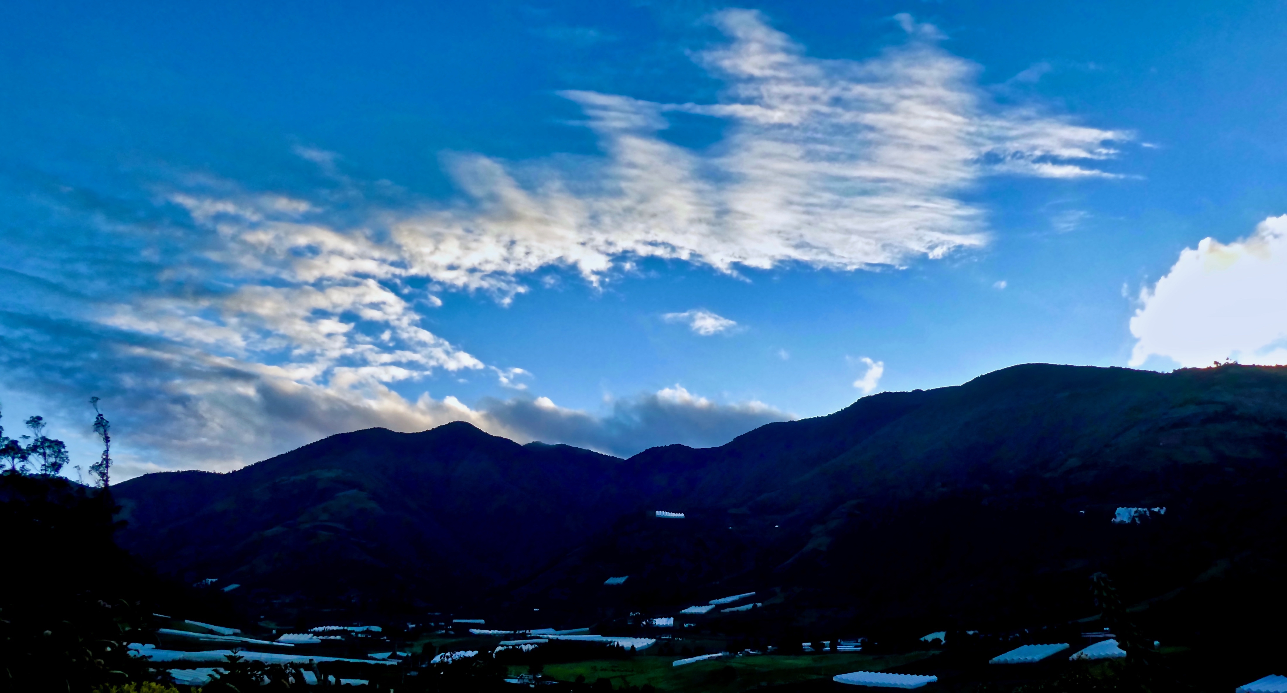
Baños sunset

Ecuador, Feb 2017, Baños de Agua Santa

Ecuador, Feb 2017, Baños de Agua Santa

Ecuador, Feb 2017, Cantón Baños
White haze!

Ecuador, Feb 2017, Baños de Agua Santa

Ecuador, Feb 2017, Baños de Agua Santa

Ecuador, Feb 2017, Baños de Agua Santa

Sunset over Baños

Ecuador, Feb 2017, Baños de Agua Santa

The sunset, looking almost straight up at the huge mountain next door

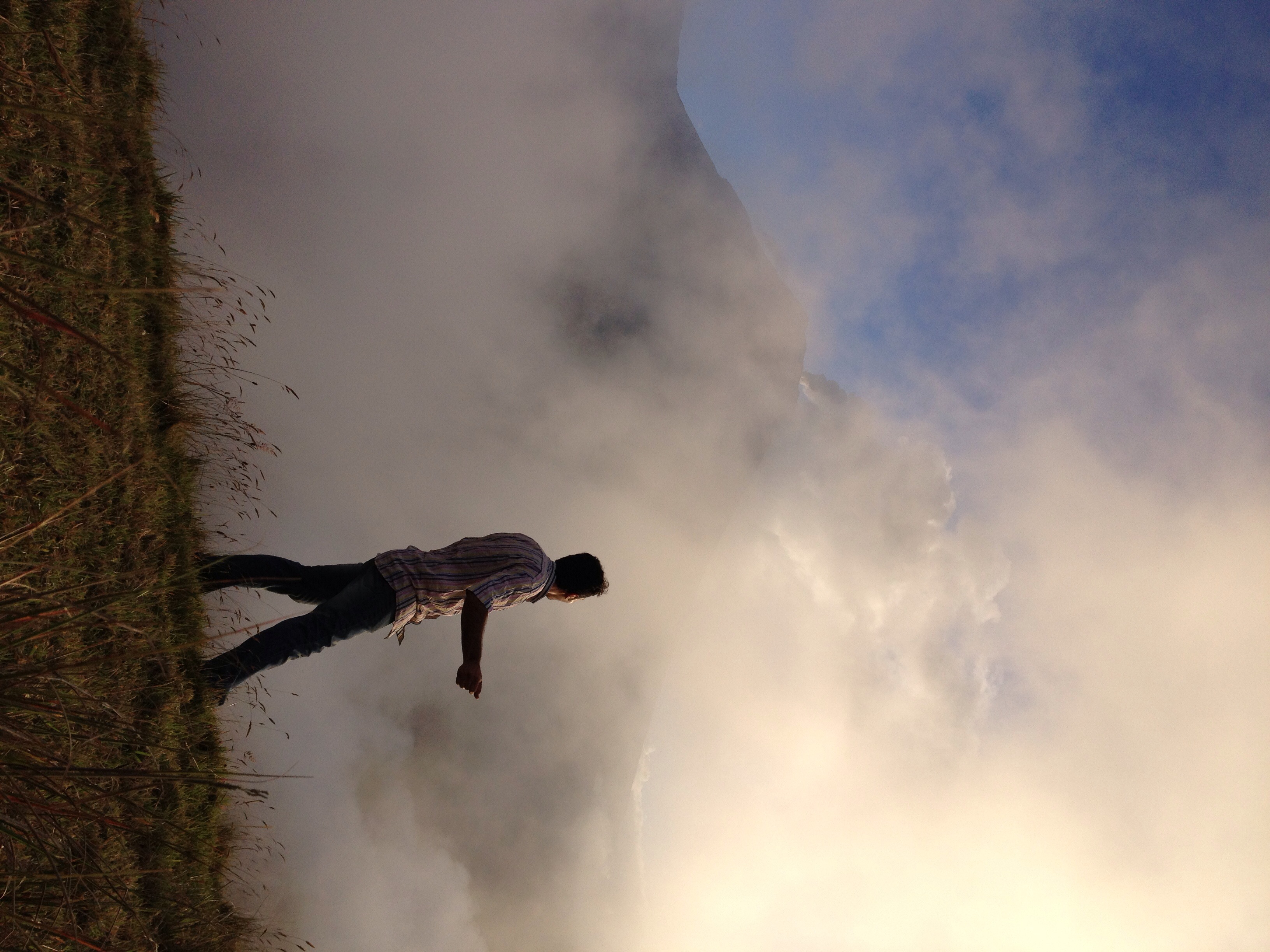
Sunrise, Climbing the Summit of the Active and Mighty Stratovolcano 'Tungurahua' ('Throat of Fire' volcano) at 5,023 meters (16,479 feet) above sea level, Baños, the Central Highlands, Ecuador.

The Crater, Climbing the Summit of the Active and Mighty Stratovolcano 'Tungurahua' ('Throat of Fire' volcano) at 5,023 meters (16,479 feet) above sea level, Baños, the Central Highlands, Ecuador.

Climbing the Summit of the Active and Mighty Stratovolcano 'Tungurahua' ('Throat of Fire' volcano) at 5,023 meters (16,479 feet) above sea level, Baños, the Central Highlands, Ecuador.
Sunrise at Hacienda Leito

Banos - Ecuador

Valley Sunrise

19981204-002
Mapa de Ulba, Ecuador
Buscar otro lugar
Lugares cercanos
Luna Runtun, Adventure SPA, Vía a Runtún, Ecuador
La Posada del Arte, Calle Montalvo &, Ibarra, Baños de Agua Santa, Ecuador
Hotel Volcano, Rafael Vieira, Baños de Agua Santa, Ecuador
ECUADOR AMAZON JUNGLE TOURS, 16 de Diciembre y Juan Montalvo, Baños de Agua Santa, Ecuador
Vía Baños Puyo, E30, Ecuador
Cascada Manto de la Novia, Th. Halflants entre Ambato y Rocafuerte, Baños de Agua Santa, Ecuador
Baños de Agua Santa, Ecuador
Pailon Del diablo, Baños de Agua Santa, Ecuador
Eco Zoologico San Martin, Baños de Agua Santa, Ecuador
El Pailon del diablo, Baños de Agua Santa, Ecuador
Cantón Baños, Ecuador
Cantón Pelileo, Ecuador
Pelileo, Ecuador
Salasaca, Ecuador
Tungurahua, Ecuador
Amazon Jungle Resort, Río Aguarico, Cuyabeno, Ecuador
Parroquia La Península, Ambato, Ecuador
Barranquilla, Ambato, Ecuador
Píllaro, Ecuador
Ambato, Ecuador
Búsquedas recientes
- Horas de salida y puesta de sol de Steadfast Ct, Daphne, AL, USA
- Horas de salida y puesta de sol de Horton in Ribblesdale, Settle BD24 0HB, Reino Unido
- Horas de salida y puesta de sol de Rojo Ct, Atascadero, CA, EE. UU.
- Horas de salida y puesta de sol de Lumagwas Diversified Farmers Multi-Purpose Cooperative, Lumagwas, Adtuyon, RV32+MH7, Pangantucan, Bu
- Horas de salida y puesta de sol de 12 Hutchinson Woods Dr, Fletcher, NC, EE. UU.
- Horas de salida y puesta de sol de Santa María del Mar, Perú
- Horas de salida y puesta de sol de Holloway Ave, San Francisco, CA, EE. UU.
- Horas de salida y puesta de sol de 1-chōme-1-5 Asahi, Utsunomiya, Tochigi -, Japan
- Horas de salida y puesta de sol de Bist Hazari, Afganistán
- Horas de salida y puesta de sol de 82- D Rd, Captain Cook, HI, EE. UU.